Japan Earthquake | Page 1942
 @es when the workers are talking about #1s magma being underground no validation yetby elainekirk 7/16/2011 1:26:40 PM
 @Bobby1 It's been posted here before, but I find the details of this accident in Brazil most astonishing/alarming, involving a mere thimble-sized quantity of radioactive cesium chloride : en.wikipedia.orgby es 7/16/2011 1:30:21 PM
- cesium in pigs but it below the reference hahaha the reference is??? www.mhlw.go.jpby elainekirk 7/16/2011 1:33:50 PM
- @elainekirk Well I'm not sure where else the corium would be by now! Some details/imaging from TEPCO would be good.by es 7/16/2011 1:36:17 PM
 Chusonji temple, national treasure, dates from 1124. 0.88 uSv/hr inside. www.japan-guide.com translate.google.comby Bobby1 7/16/2011 1:38:06 PM
- Professor Takeda: contaminated milk shipped across Japan translate.google.comby Bobby1 7/16/2011 1:51:11 PM
 Hi all!
@ES, reading about how you have your home set up. That is great, you could teach people in other places quite a bit about how to do it. People in the US have been so brainwashed that alternative energy doesn't work. They need people to show them it does.by lillymunster 7/16/2011 1:52:16 PM- If anyone still has the link to the Tokyo mushrooms grown indoors that were radioactive can you repost it. I missed grabbing it. With all these new finds you all listed just now I think we could make a website article out of it.by lillymunster 7/16/2011 1:57:06 PM
- @lillymunster did I put a link when I posted it I will go lookby elainekirk 7/16/2011 2:05:28 PM
- @lillymunster We need to look backwards as well as forwards here. There are scores of nifty ways of reducing energy consumption, and the 'developing' world can teach us lots too. Whilst living in the dark and dismal UK I experimented with powering my laptop through the long month of January using a very cheapo car battery charger - a small PV panel which plugs into the cigarette lighter. I hooked it up to a small motorcycle battery and it produced enough power through the day (on my brightest windowsill) to charge both the battery and my laptop so that when darkness fell I still had several hours worth of use. I'm currently planning on constructing a fridge/cooler out of layered chicken-wire filled with wet sand and carbon - the air cools via evaporation. These sorts of things have been in use for most of human history, don't forget!by es 7/16/2011 2:06:24 PM
- @es I used to do living history, there are lots of old technologies to get by. I ordered a solar phone charger last week. Have been thinking of picking up one of those small panels to charge my laptop but your idea is intriguing. Having a battery involved would solve running out of laptop battery at night. What do you use to go from the battery to the device?by lillymunster 7/16/2011 2:09:35 PM
- @lillymunster indoor mushroom story www.asahi.comby elainekirk 7/16/2011 2:12:50 PM
- @lillymunster You need some sort of inverter. I used a cheap (20 dollars-ish) 'Car Power Point' that plugs into the lighter socket. This connects easily to the battery terminals.by es 7/16/2011 2:12:51 PM
- @es The cooler you are constructing is similar to a swamp cooler, which are popular in the US southwest, areas with low humidity.by Bobby1 7/16/2011 2:20:29 PM
- @Bobby1 Yes, exactly.by es 7/16/2011 2:20:56 PM
- @Bobby1 It's virtually desert here!by es 7/16/2011 2:21:22 PM
- @Elaine, thanks! The number of contamination stories coming out is mindboggling. We knew this was going to happen to some extent but it really seems to be becoming worse.
@ES, we use those kinds of inverters commonly in the US for other things. Thought maybe there was something else to use. They are really expensive here. Just replaced the one we use for emergency power and it was almost $80by lillymunster 7/16/2011 2:21:51 PM - @lillymunster Yes, some are expensive, and clearly the bigger your set-up, the more expensive the gear. I bought the cheapest and smallest available. I'd be surprised there's nothing cheaper than $80, though I bought that little one maybe eight years ago, and it still works! Incidentally, boats often use RO systems and seem to upgrade them fairly frequently - I've seen several come up for sale at coastal auctions. Actually I got pipped at a sale last month when my self-imposed limit and upper bid for a nice looking RO kit was 15 euros. It went for 17. Doh!by es 7/16/2011 2:33:09 PM
- @es good to know. Dean found a company that has a media filter that looks like it can remove radiation contamination and fits into a whole house filter canister.
The inverter was a big one, need it to run the hubby's cpap if the power goes out.by lillymunster 7/16/2011 2:35:38 PM 
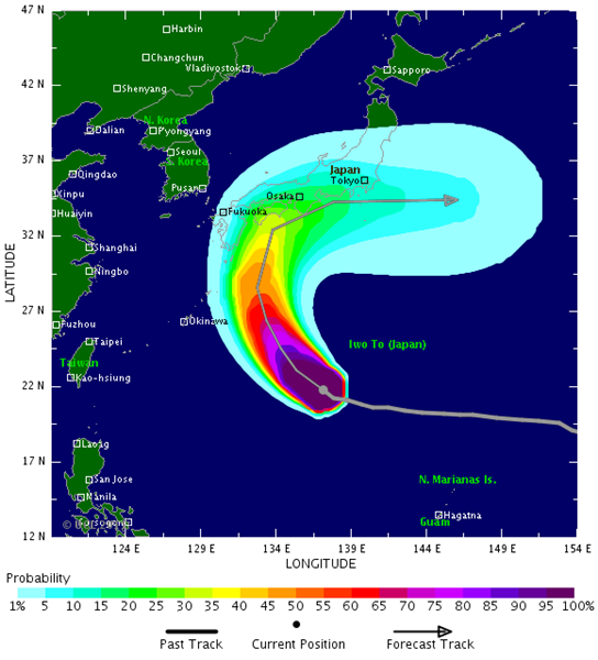
Typhoon Ma-on ; As of late Saturday morning, EDT, the center of Typhoon Ma-on was near 22 north and 136 east, or about 200 miles south-southwest of Iwo Jima, Japan. Movement was to the west-northwest at 10 mph. Maximum-sustained winds were near 125 mph with gusts to 150 mph.
Ma-on is currently over open water. The typhoon is expected to continue on a west to northwest direction over the next 24 hours, then start turning more northwest to north and eventually to the northeast. Some intensification will occur during this time and Ma-on could become a super typhoon as early as tonight. Southern Japan will be in the direct path of Ma-on early next week. While there may be some weakening by that point, due to stronger wind shear aloft, but Ma-on is still expected to be a strong typhoon and will pose a severe threat to Japan with flooding rain and destructive winds and high surf. Right now it looks like the greatest impact will be from Kyushu north into southern Honshu. However, flooding rain and strong winds will eventually move north and will threaten areas of northern Japan hit hard by this March's earthquake and tsunami. recent thinking is that the typhoon may track farther west and the recurvature is a bit slower than we first thought.
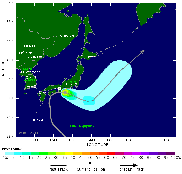
By AccuWeather.Com Meteorologist Mark Paquette. www.tropicalstormrisk.com Typhoon MA-ON: Probability of Cat 1 or above winds to 120 hours leadby Majj via Tropicalstormrisk 7/16/2011 2:39:30 PM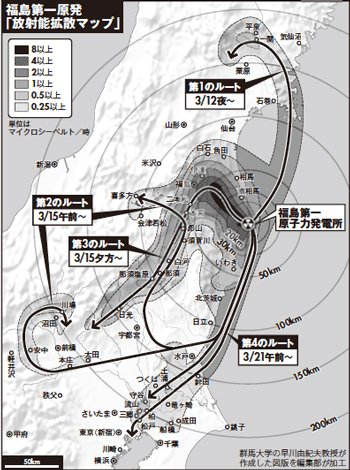
Notice how the plume from the March 21 radiation release event from #3 headed straight to Tokyo. ok-life.sakura.ne.jp
by Bobby1 via Ok-life.sakura.ne.jp 7/16/2011 2:43:01 PM- @all, we need to determine what phone and mobile device OS is most common in Japan iPhone, Android, something else, or split evenly. The company developing the rad detectors wants to know if they should write the software in something other than iPhone.by lillymunster 7/16/2011 2:48:42 PM
- They don't say how or how soon but removing spent fuel from 3 & 4 became a priority www.japantoday.comby lillymunster 7/16/2011 3:45:43 PM
 Morning all! @Lilly NHK has the mushroom story now as well.... Radioactive cesium detected in Fukushima shiitake
Radioactive cesium exceeding the government standard has been detected in shiitake mushrooms grown indoors in 2 cities in Fukushima Prefecture, about 60 kilometers from the troubled Fukushima Daiichi nuclear plant. This is the first detection of radioactive cesium exceeding the standard in produce grown in greenhouses in the prefecture since the nuclear accident.
The Fukushima prefectural government says 1,770 becquerels per kilogram of radioactive cesium was detected in mushrooms grown in Date City. The level is more than 3 times the provisional government limit of 500 becquerels per kilogram.
560 becquerels of radioactive cesium was detected in mushrooms from Motomiya City.
At least 157 kilograms of shiitake mushrooms from the 2 cities were shipped from early July through Friday to Tokyo, a supermarket in Fukushima City, and a local farmers' market. www3.nhk.or.jpby LM 7/16/2011 3:46:18 PM- @all Does anyone have data for drinking water in the Fuku area? I find it hard to believe it's not teeming with radioactivity. Rad water would explain greenhouse plant contamination.by LM 7/16/2011 3:48:44 PM
- @LM There is some drinking water testing. Can't find the link at the moment.by lillymunster 7/16/2011 4:01:10 PM
- @Lilly They must have increased the drinking water limit so everything is just fine!by LM 7/16/2011 4:03:31 PM
 The mushrooms may have gotten the contamination from the growing medium, it's manure I think.by Ralph Unger 7/16/2011 4:11:42 PM
- @Ralph That makes sense as well.by LM 7/16/2011 4:12:19 PM
- W7VOA Steve Herman
Largest supermarket chain in #Japan (Aeon) reveals beef above legal level of Cs-137 sold for more than 45-day period in Kanto region.
1 minute agoby Majj 7/16/2011 4:15:34 PM - Per Twitter: citizen air filter tests finding tellerium. TEPCO previously found and claimed it was an error and there was none.by lillymunster 7/16/2011 4:16:51 PM
- US CDC info on cesium : The primary purpose of this chapter is to provide public health officials, physicians, toxicologists, and
other interested individuals and groups with an overall perspective on the toxicology of cesium, existing
naturally as the stable (nonradioactive) isotope 133Cs and in the form of radioactive isotopes produced
during nuclear fission, the most abundant of which are 137Cs and 134Cs. This chapter contains descriptions
and evaluations of toxicological studies and epidemiological investigations and provides conclusions,
where possible, on the relevance of toxicity and toxicokinetic data to public health. www.atsdr.cdc.govby Majj 7/16/2011 4:17:44 PM - @all I hope they're making some effort to test pork and chicken as well....Both are more widely consumed than beef in Japan.by LM 7/16/2011 4:20:59 PM
Citizens from Fukushima City make a plea to the world to relay the message that they need help. Seems they are asking for an “official” evacuation order from their Japanese government. They compare their situation to that of the Chernobyl accident. If this was Chernobyl, they would have been officially evacuated.
by Majj 7/16/2011 4:22:59 PM- @lillymunster. Smartphone OS for most countries is Nokia's Symbian but this is now being superseded by Microsoft's WP7. Where Nokia is not the smartphone of choice its Googles Android. This is because a large number of manufacturers are producing handsets using this OS. Apple's iPhone OS is mainly used in US markets but does have increasing use outside of the US due to ease of use and apps. Japan mainly uses Android at the moment.by Alphaspheric 7/16/2011 4:25:02 PM
- @Alphaspheric Thanks! That is helpful.by lillymunster 7/16/2011 4:25:34 PM
- @LM oh. Do most chicken farms let them be outside?by lillymunster 7/16/2011 4:26:22 PM
- @LM They are make all effort to NOT measure any thing. WE have to be realistic. Japan is very contaminate . Every were. Every thing. I'm so sorry for Japan. Sorry for the Planet ;-((((((by Majj 7/16/2011 4:28:07 PM
- @Lilly I'm not sure, but I'd still be concerned given issues with feed and water contamination.by LM 7/16/2011 4:28:34 PM
- @all By the way...just looked at both cams..2 and 4 are spewing away. How can they say1-3 are stanly cooled? Complete BS!by LM 7/16/2011 4:29:52 PM
- Stably not stanly.by LM 7/16/2011 4:30:23 PM
- Consequences of the Fukushima Daiichi Accident in Japan : A substantial and long-lasting contamination
The CRIIRAD institute went on a mission in Japan from May 24th to June 3rd, 2011. The present document gives account of the findings from the first analysis results. The radioactive cesium deposits on the soils have been of great magnitude. They generate, and will continue to do so for a long time to come, a flux of gamma radiation causing the irradiation of populations in widespread areas. Due to this external exposure and in the absence of protective measures, several hundreds of thousands of people will receive radiation doses far above the limit of 1 mSv/year. Must be added, the internal exposure (due to ingestion of contaminated foods) and doses received since March 12th that were extremely elevated during the first week from the level of contamination and the lack of protective measures. www.europe-solidaire.orgby Majj 7/16/2011 4:32:01 PM - @Majj Definitely true...the contamination is widespread.by LM 7/16/2011 4:33:32 PM
- @all All 4 are steaming.by LM 7/16/2011 4:35:13 PM
- That video is heartbreaking. How does anyone do something to pressure the govt. to help them evacuate? Who do you write to, who do you complain to? I think people removed from the situation don't understand that unless you have lots of money you probably can't move. You would probably lose your job by moving and would need to pay not just to take your stuff and go but to have somewhere to live and pay for it.by lillymunster 7/16/2011 4:37:43 PM
Japan Earthquake | Page 1942
- Who's Blogging
-
 hudebnik
 alblee
 UKVal
UKVal Jonathan Keebler
 Oliver (ScribbleLive)
 kaykodh
 Markfm
 Angie
Angie Mid Valley
 Matt (ScribbleLive)
 George Gibb
- elainekirk
 PKelley
- lillymunster
 dean
dean bo
bo Edano
Edano Deb
Deb- Pedro Jesus
 IanGoddard