Japan Earthquake | Page 2329
 Japan may set up nuclear safety training institute
TOKYO, Sept. 11, Kyodo
Japan will consider setting up a nuclear safety training institute to improve the quality of human resources involved in nuclear safety, according to an updated government report on the nuclear crisis at the Fukushima Daiichi nuclear power plant.
The report, which will be submitted to the International Atomic Energy Agency ahead of its general conference later in the month, also said work to contain the crisis at the Fukushima Daiichi plant is proceeding steadily, but ''several more months'' are needed to bring damaged reactors to a state known as ''cold shutdown.''
At the outset of a government meeting on Sunday to endorse the report, Prime Minister Yoshihiko Noda said that the fight to contain the nuclear crisis is ''still halfway.'' english.kyodonews.jpby Edano 9/11/2011 2:13:50 PM TBS set their live FukuCam to Private : www.youtube.com Sup with that? Is there a public TBS feed?by Ian 9/11/2011 2:13:56 PM
 wwwndc.jaea.go.jp
International Conferences, Symposiums and Meetings
Related to Nuclear Data
One for the site maybe?by elainekirk 9/11/2011 2:15:07 PM- This is the attribution link you can put a yt-video ID into to see its host www.youtube.comby Ian 9/11/2011 2:16:18 PM
 This link to TBS cam works - of course it is dark out but it is a live broadcast. www.youtube.comby lillymunster 9/11/2011 2:21:41 PM
 another link to tbs cam. www.youtube.comby M.I.A. 9/11/2011 2:23:38 PM
- @Edano, that reminds me that long before Tanabe's thesis, I saw some graphs that attributed the radiation spike around Mar 21 in outlying areas to 'first rain'. Give there was no increase in Unit-3 drywell radiation, that makes more sense to me. But what I can't figure in that document is how Tepco can show in that first graph the water injection levels falling to zero and then say: "It is unlikely that the rate of actual water injection to the reactor reduced." Seems to me the explanation for the dark smoke on Mar21-23 is less water cooling already-fallen corium that then started to heat up and burn concrete.by Ian 9/11/2011 2:24:43 PM
- @M.I.A. @lillymunster , thanks !!! Last time they changed it I lost track.by Ian 9/11/2011 2:26:38 PM
- Asuperdry has another video. Took a reading of the road in Kashiwa near Tokyo. It is a fairly steep hill that should have had plenty of water washing over it due to the typhoons. www.youtube.comby lillymunster 9/11/2011 2:30:05 PM
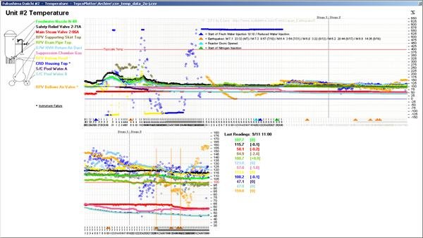
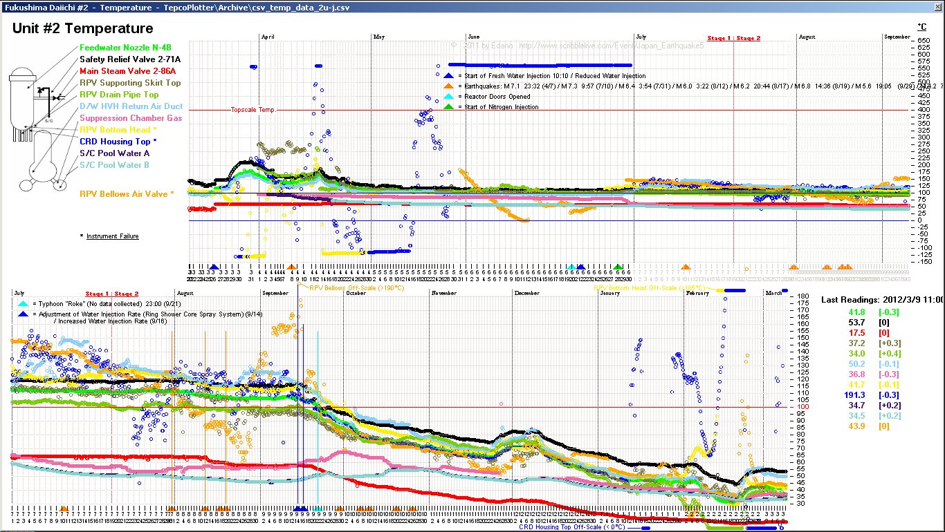
www.houseoffoust.com
the highest temperature in #2 is in the drywell "HVH Return Air Duct" (light blue), not in the rpv (if you neglect the crazy Bellows valve (orange) and Control Rod Housing (dark blue))by Edano via Houseoffoust 9/11/2011 2:34:42 PM- @lillymunster did you get the nuke links link I posted should be usefulby elainekirk 9/11/2011 2:35:22 PM
- @elainekirk yes, grabbed it for the siteby lillymunster 9/11/2011 2:37:12 PM
- diagram of the cooling system it looks as though 1-3 are interdependent and if a fault develops it will impact all 3 reactors but that is just my non techi take on it www.tepco.co.jpby elainekirk 9/11/2011 2:42:13 PM
- Symposium on the Accident of
2011 NIRS - 2011 NIRS - IAEA IAEA -- REAC/TS Training Course: REAC/TS Training Course: International Medical Management of Rad International Medical Management of Radiation Incidents iation Incidents
TEPCO TEPCO Fukushima Fukushima Daiichi Daiichi Nuclear Nuclear Power Power Station Station
-What was seen and not seen by Others? -What was seen and not seen by Others?--
www.nirs.go.jp
should I look see if I can find what was discussed AT THhis ?by elainekirk 9/11/2011 2:45:29 PM 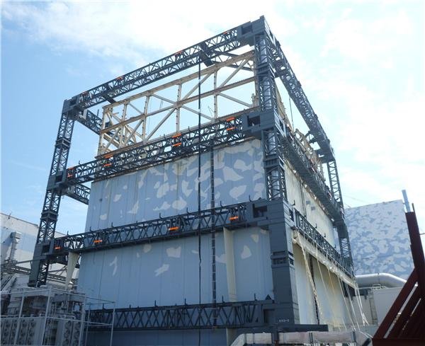
www.tepco.co.jp check the original link, it's hi res
by Edano via Tepco.co.jp 9/11/2011 2:49:01 PM
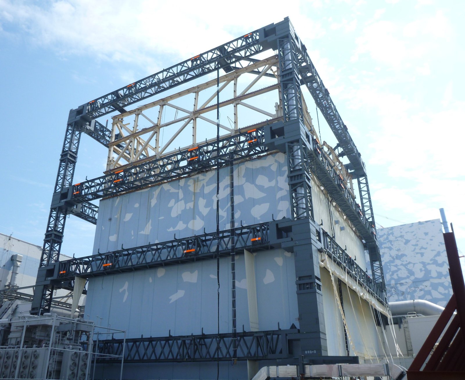
TEPCO Fukushima Daiichi Reactor 1 Sarcophagus Construction: Beam-to-column connection
by Deb 9/11/2011 2:49:11 PM- Peace Winds America and U.S. Embassy Announce
The U.S.-Japan Civil-Military Initiative
“Disaster Preparedness Workshop
September 27-29, 2011
U.S. Embassy, Tokyo, Japan
reliefweb.intby elainekirk 9/11/2011 2:50:34 PM - @Edano, does any of the reactors data show behavior that might account for the i-131 spike on late August? fukushima-diary.com Maybe a quake jarred hardened corium and triggered a criticality? Just a wild guess.by Ian 9/11/2011 2:51:55 PM
- @elainekirk makes me wonder what they will discuss? How Japan botched the disaster?by lillymunster 9/11/2011 2:52:55 PM
- @lillymunster or to prepare for the (inevitable) next oneby elainekirk 9/11/2011 2:54:14 PM
- asuperdry also just posted this one, with readings higher than the other : www.youtube.comby Ian 9/11/2011 2:56:05 PM
- @Ian yes we had lots of quakes in august. and we had the high >10 Sv readings around #1 and steam coming out of the soil and >400 Sv/hr in the rpv. but the 4 cities all are about 300 km from fuku and positioned in all directions from fuku, nearly in a circle. it's hard to find an explanation.by Edano 9/11/2011 2:57:26 PM
- @Ian did you get the link @edano highlighted for you www.tepco.co.jp was that the one @edano?by elainekirk 9/11/2011 3:03:36 PM
 9/11 Anti-Nuclear Protest pics - police scuffle - posted by irockhopper bmkimages.photoshelter.comby Mid Valley 9/11/2011 3:06:05 PM
- @elainekirk no, this one: ian has to see this doc www.tepco.co.jpby Edano 9/11/2011 3:09:06 PM
- @elainekirk, sorry, I missed that. Okay I see Edano's cites another. Okay, yes I saw that and commented below....by Ian 9/11/2011 3:10:11 PM
- It looks as though the citizens were easily overidden on the initial decision to allow tepco to use mox fuel , this jaif paper is 1999
According to the group seeking citiz ens ’ r e f e r endums , 26,690 s igna tur e s
were collected in Kashiwazaki (38% of
the eligible voters), and 1,354 in Kariwa
(32%). The Kashiwazaki percentage was
more than the one-third required to force
a v o t e o n r e c a l l i n g t h e m a y o r . T h e
Kashiwazaki city assembly was scheduled to debate the issue and vote on a
referendum ordinance on March 23. No
dates have been set yet in Kariwa.
The number of signatures collected
clearly means a great many people are
concerned. Mayor Saikawa has, however, said for some time: “National issues, which cannot be resolved locally,
are not appropriate questions for citizens’ referendums.” www.jaif.or.jpby elainekirk 9/11/2011 3:12:40 PM - GOVERNMENT OF JAPAN
September 2011
1.The occurrence of The Great East Earthquakes
Unprecedented challenge for Japan since 3・11 ・・・3
Emergency efforts ・・・4
Foreign assistance and rescue efforts ・・・6
Cause of the Accident and Damage at Fukushima Dai-ichi
Nuclear Power Station ・・・7
Nuclear Power Stations Nuclear Reactors near Epicenter of
the Earthquake ・・・8
2.Damages, current situation and the Government,
the Local Government and Private sector of
Japan's response
Macroeconomic impact ・・・9
Estimated Economic Damage of the Tohoku-Pacific Ocean
Earthquake and Plan for Reconstruction ・・・10
Speedy reconstruction of infrastructure ・・・11
Impact on Energy Supply / Demand in Japan ・・・12
Electric supply/demand up to this summer ・・・13
Speedy recovery of supply chain beyond expectation ・・・14
Utmost effort to settle Fukushima NPS accident ・・・15
Rigorous and intensive monitoring ・・・16
Current Status of “Roadmap towards Restoration from the
Accident at Fukushima Daiichi Nuclear Power Station,
TEPCO” (Revised edition) ・・・17
Points of Progress Status of “Roadmap towards Restoration
from the Accident at Fukushima Daiichi Nuclear Power
Station,TEPCO” ・・・19
Atmospheric Readings within 100km ・・・20
Atmospheric Readings in Tokyo, Osaka and Sapporo ・・・21
Ensure the safety of food and products ・・・22
Safety of Food ・・・23
Government Actions to Ensure the Safety of Beef and Other
Food ・・・24
Safety of Fishery Products ・・・25
Safety of Drinking Water ・・・26
Safety of Industrial Products ・・・27
Radiation in Dairy-life ・・・28
3.Road to recovery
Reconstruction open to the world ・・・29
Basic Guidelines for Reconstruction in response to the Great
East Japan Earthquake(decided on July 29,2011) ・・・30
On Strategies for Revitalizing Japan(August 5, 2011) ・・・31
Decision of the Energy and Environment Council(July 29,
2010) ・・・35
4.Assistance from overseas
Map of sites where rescue teams from foreign countries,
regions, and international organizations are operating (3rd
August)
www.kantei.go.jp ・・・3by elainekirk 9/11/2011 3:37:06 PM 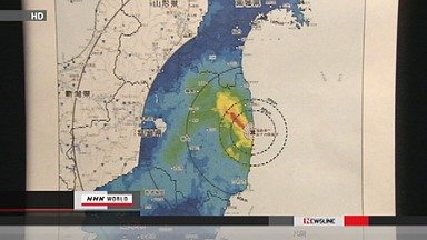
www3.nhk.or.jp
High levels of radiation found in remote areas
Japan's science ministry has compiled a map showing radiation levels in Fukushima and 4 surrounding prefectures, based on the results of an aerial survey.
Removal of radioactive substances will be required in the affected areas.
In the map, levels of radioactivity at locations one meter above the ground are highlighted in different colors.
Red is for areas where the radiation level is 19 microsieverts per hour or higher.
The red band spreads from the crippled Fukushima Daiichi nuclear power plant to the northwest and extends about 30 kilometers.
Areas with radiation levels of 3.8 microsieverts per hour or above are highlighted in yellow. The figure translates to above 20 millisieverts per year, a threshold in designating an evacuation zone. The yellow area extends beyond the current evacuation zone.
Light green shows levels between 0.5 and one microsieverts per hour. They still are far beyond the annual level of one millisievert which is believed to cause no harm to people. Much of Fukushima Prefecture, southern parts of Miyagi Prefecture, and northern parts of Tochigi and Ibaraki prefectures lie in this zone.
Sunday, September 11, 2011 10:49 +0900 (JST)
www3.nhk.or.jpby Edano via Www3.nhk.or.jp 9/11/2011 3:37:55 PM- @elainekirk Kashiwazaki was the only area that rejected MOX use IIRC. There were all those stories around July of power companies stacking meetings and email feedback with employees posing as citizens who wanted MOXby lillymunster 9/11/2011 3:40:03 PM
- Minami Soma residents clean streets for children
Residents of Minami Soma City in Fukushima Prefecture continue to clean up roads used by elementary and junior high school students 6 months after the nuclear accident.
The city's Masuda district is less than 30 kilometers from the Fukushima Daiichi power plant, and residents have been advised to be prepared to evacuate immediately when another emergency situation occurs.
The elementary and junior high schools in the area remain closed.
On Sunday, more than 30 people cleaned up a 500-meter stretch of a road that will be used by children when the schools reopen.
They measured radiation levels as they washed the sidewalks with high-pressure equipment and removed dirt from the sides of the road with spades.
Thanks to their efforts, radiation levels in some places have fallen from 3.6 microsieverts per hour to about one-third of that level.
The head of the district, Hirotoshi Kobayashi, says people are trying to protect the area by themselves.
He says he will work to lower the radiation levels and rebuild a community where children can go to school safely.
Minami Soma City plans to continue cleaning up roads and parks with the help of people from other districts.
Sunday, September 11, 2011 22:59 +0900 (JST)
www3.nhk.or.jpby Edano 9/11/2011 3:40:47 PM - and why doesn't tepco do that ?????by Edano 9/11/2011 3:41:04 PM
- why do they leave that to the people ? unbelievable.by Edano 9/11/2011 3:42:43 PM
- @Edano corporations have no sympathy or involvement with society. Their only goal is to make money. All their efforts are going into censoring, PR and legal maneuvering to avoid lawsuits. This is all they do and expecting a corporation to do more without a good enough threat from something powerful enough to crush them is wishful thinking.
by lillymunster 9/11/2011 3:44:33 PM - @lillymunster if the govj had balls, they would force them to clean up the streets.by Edano 9/11/2011 3:50:28 PM
- lick them up.by Edano 9/11/2011 3:51:56 PM
- @Edano or the govt would do it and send them the bill. Could they use the SDF to help with this? What ever happened to liquidating TEPCO to pay for all this mess? Letting them continue to operate as a company gives them more motivation to lie and obstruct in order to keep their stock price high.by lillymunster 9/11/2011 3:52:50 PM
- Did we know that Japan have just this month submitted a new report to the IAEA?
www.meti.go.jp
The Ministerial Declaration and the Chair’s Summary of the Conference’s plenary
session state expectations towards Japan for the continued provision of information. The
government recognizes that it is incumbent upon Japan to continue to provide accurate
information regarding the accident to the international community, including lessons
learned through the accident. In accordance with this approach the Government of Japan
decided to compile information on the state of affairs subsequent to the June report in
the form of an additional report and submit it to the IAEA on the occasions of the Board
of Governors meeting and the General Conference.by elainekirk 9/11/2011 3:56:24 PM  Ah...coffee and news. @lillymunster Nice 6-month catchup on the site.by RadioGuy 9/11/2011 4:40:05 PM
- @RadioGuy thanks! Just made coffee too. :-)by lillymunster 9/11/2011 4:41:07 PM
- I wonder if there's really a difference between those two in who pays for the cleanup. If GoJ pays for it all and sends the bill to TEPCO, they go belly up, and GoJ has to pick it up anyway. I tend to think for now TEPCO is a useful buffer and scapegoat. Is there really enough money anywhere to pay for this mess?by RadioGuy 9/11/2011 4:44:28 PM
- @RadioGuy I wonder that also when you look at the real cost of the massive decontamination, or evacuating everyone that really should be. The cost is staggering. I wonder how it matches up with the total finances of the govt. Japan is an advanced first world country but they are finite in resources and land.
My opinion on this mess is they should be evacuating everyone out of the 50km zone and further around that north west blob of high radiation. Then go from the least contaminated area and work your way back. That makes the further out areas as safe as can be and also the ones most likely to succeed. Then go incrementally into the higher areas attempting to decontaminate until you find that the progress vs. the available efforts don't make sense. Call that the no go zone border.by lillymunster 9/11/2011 4:52:13 PM - @lillymunster have you noticed in the report to the iaea in sept they imply that the blob zone is evac'ed?by elainekirk 9/11/2011 5:02:15 PM
- Does anyone know where I could find some stats on all the people who worked at Chernobyl or got exposed but don't have any compensation for related illnesses? Reading the blog post on the faux symposium from earlier today. Would be a good tie in to talk about all the people left without help after Chernobyl.by lillymunster 9/11/2011 5:03:53 PM
- @elainekirk how much of it is evacuated? I remember some prepare to evacuate areas and one secondary evacuation but don't know the extent of it. What about the hot spot evacuations they are in other places IIRC.by lillymunster 9/11/2011 5:05:32 PM
Japan Earthquake | Page 2329
- Who's Blogging
-
 hudebnik
 alblee
 UKVal
UKVal Oliver (ScribbleLive)
 Jonathan Keebler
 kaykodh
 PKelley
 Markfm
 Angie
Angie- Deb
 Mid Valley
- Pedro Jesus
 Matt (ScribbleLive)
 George Gibb
- elainekirk
- lillymunster
 dean
dean bo
bo- Edano
 IanGoddard