Japan Earthquake | Page 2917
 Someone says this is all on "fault 33" and is a dangerous very active fault? www.zakzak.co.jpby lillymunster 1/27/2012 11:46:56 PM
 I went to look iceland only 24 quakes in past 48hrs compared to usual 100plusby elainekirk 1/27/2012 11:47:20 PM
 hmm, don't know where fuji is located exactly ...by Edano 1/27/2012 11:47:24 PM
 www.yamanashi-kankou.jp looks to be a good website,,I think the quake information is from the march 2011.. bye maybe a good sourceby dean 1/27/2012 11:47:34 PM
- @elainekirk.. hi .. where you been... lolby dean 1/27/2012 11:47:48 PM
- @Edano maps.google.co.ukby elainekirk 1/27/2012 11:49:08 PM
- aah, it was tepco's fault again:
Tepco Starts Solar Plant in Japan’s Yamanashi Prefecture www.bloomberg.comby Edano 1/27/2012 11:49:20 PM - been watching just 'hectic' at home/travellingby elainekirk 1/27/2012 11:49:50 PM
- @elainekirk ah, yamanashi is mt. fuji indeedby Edano 1/27/2012 11:51:00 PM
- www.sfgate.com reports on earthquake,, they hope mt fuji doesn't eruptby dean 1/27/2012 11:51:19 PM
- @Elaine.. very nice seeing youby dean 1/27/2012 11:51:32 PM
- @Edano *shiver* all that construction for the solars how effective are radioactive solar panelsby elainekirk 1/27/2012 11:51:49 PM
- good to be chatting againby elainekirk 1/27/2012 11:52:25 PM
- vulcan.wr.usgs.gov web site for misc volcano web cams.. hope it helpsby dean 1/27/2012 11:55:43 PM
- @elaine.. indeedby dean 1/27/2012 11:55:52 PM
- 10 car pile up in Osaka. No word if they felt the quake or not. The pileup was among the time of the quakes www3.nhk.or.jpby lillymunster 1/27/2012 11:56:55 PM
- @lillymunster porsches and maseratis again ? ;)by Edano 1/27/2012 11:58:13 PM
- Japan meterological will have a press conf at 9:45 JSTby lillymunster 1/27/2012 11:58:42 PM
- @Edano didn't sound like early morning racing. Sounds rather nasty though.by lillymunster 1/27/2012 11:59:16 PM
 odd. Could just be sun, but I've just seen a lot of flashes in #4 on TBS camby UKVal 1/27/2012 11:59:39 PM
- @UKVal check what side they are coming from vs. sunrise. They get some odd sun reflections early morning.by lillymunster 1/28/2012 12:00:15 AM
- 5.2
Mercalli scale: 5
Date-Time [UTC]: 27 January, 2012 at 22:43:15 UTC
Local Date/Time: Friday, January 27, 2012 at 22:43 in the evening at epicenter
Location: 35° 32.544, 138° 57.588
Depth: 26.40 km (16.40 miles)
Region: Asia
Country: Japan
Distances: 5.20 km (3.23 miles) of Okubo, Yamanashi-ken
Source: USGS-RSOE
Generated Tsunami: Not or no data!
Damage: Not or not data!
Additional information (Radius of 100 km)
Nuclear facilities: There are no nuclear facilities nearby the epicenter.
Airport(s):
Location Airport ICAO Type Distance
Japan Atsugi Airport RJTA 28.22 km
Japan Iruma Airport RJTJ 32.66 km
Japan Kastner Aaf Airport RJTR 24.45 km
Japan Kisarazu Airport RJTK 54.35 km
Japan Tokyo (haneda) International Airport Airport RJTT 46.06 km
Volcanoes:
Location Volcano Type Last eruption Distance
Izu Is-Japan Oshima Stratovolcano 61.88 km
Honshu-Japan Tateshina Stratovolcanoes 53.35 km
Honshu-Japan Izu-Tobu Pyroclastic cones 45.03 km
Honshu-Japan Hakone Complex volcano 21.87 km
Honshu-Japan Fuji Stratovolcano 18.10 km
hisz.rsoe.huby Edano 1/28/2012 12:01:37 AM - what were the abnormal conditions that occured the other day ? www.tepco.co.jpby elainekirk 1/28/2012 12:10:44 AM
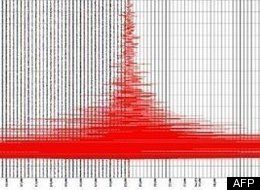
seismic recording of yamanashi EQ
by dean 1/28/2012 12:10:51 AM- @dean cripes!by elainekirk 1/28/2012 12:11:42 AM
- www.huffingtonpost.com — A magnitude-5.5 earthquake rattled Yamanashi prefecture in central Japan on Saturday morning, the Japan Meteorological Agency reported. There were no immediate reports of damage or injuries, and no tsunami warning was issued.
The temblor was some 20 kilometers (12 1/2 miles) deep and hit at 7:43 a.m. local time (2243 GMT Friday), the Japanese earthquake-reporting agency said.by dean 1/28/2012 12:13:12 AM - @Edano.. I posted that as comparison.. different sources sure like to jump on the reportby dean 1/28/2012 12:13:56 AM
- www.thehindubusinessline.com (Japan), Jan. 27:
A solar power plant with an output capacity of 10 MW, which is enough to supply power to around 3,400 homes, began operations on Friday here.
The Komekurayama solar power station, built by Tokyo Electric Power Co. on a 12.5 hectare site, is one of the largest photovoltaic power plants in Japan.
The site is being leased free of charge by the Yamanashi Prefectural government.
Landlocked Yamanashi Prefecture, which enjoys relatively long hours of sunshine, is trying to attract establishment of solar power plants in the region.
In addition to the one here, other projects are in progress in the cities of Kai and Nirasaki.
Tokyo Electric is the operator of the troubled Fukushima Daiichi nuclear power plant.by dean 1/28/2012 12:18:30 AM - hope the earthquake didn't take out the new solar panels.. I don't think they have any seismic requirements at allby dean 1/28/2012 12:19:29 AM
- Itsumi says the concern is that the quakes are connected to mt Fujiby elainekirk 1/28/2012 12:20:45 AM
- Seeing a mention of 5.2 at 9.23am can someone confirm? On my phoneby lillymunster 1/28/2012 12:31:19 AM
- @lilly.. please send that gmail back .. geeeeeeeze.. I don't have the contents now.. duhby dean edited by lillymunster 1/28/2012 12:31:21 AM
- Dean will check when home in a fewby lillymunster 1/28/2012 12:33:05 AM
- another quake?by elainekirk 1/28/2012 12:33:25 AM
- Magnitude 5.2
Date-Time
Friday, January 27, 2012 at 22:43:15 UTC
Saturday, January 28, 2012 at 07:43:15 AM at epicenter
Time of Earthquake in other Time Zones
Location 35.542°N, 138.960°E
Depth 26.4 km (16.4 miles)
Region EASTERN HONSHU, JAPAN
Distances 36 km (22 miles) ESE of Kofu, Honshu, Japan
49 km (30 miles) N of Numazu, Honshu, Japan
61 km (37 miles) W of Yokohama, Honshu, Japan
73 km (45 miles) WSW of TOKYO, Japan
Location Uncertainty horizontal +/- 14 km (8.7 miles); depth +/- 7.7 km (4.8 miles)
Parameters NST=197, Nph=197, Dmin=130.2 km, Rmss=0.67 sec, Gp=104°,
M-type=body wave magnitude (Mb), Version=7
Source
Magnitude: USGS NEIC (WDCS-D)
Location: USGS NEIC (WDCS-D)by dean 1/28/2012 12:35:46 AM - I was sure I posted the iwate quake ...by elainekirk 1/28/2012 12:45:41 AM
- @elainekirk you did - it disappearedby UKVal 1/28/2012 12:46:17 AM
- Type: Earthquake
26 minutes ago
Magnitude: 5.6
DateTime: Saturday January 28 2012, 00:22:16 UTC
Region: near the east coast of Honshu, Japan
Depth: 34 km
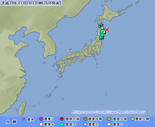
Source: USGS Feedby UKVal 1/28/2012 12:49:07 AM - by UKVal via Jma.go.jp 1/28/2012 12:50:19 AM
- ah so iwate and honshu are one and the same oops sry dean thought it was dif with it saying 5.6by elainekirk 1/28/2012 12:51:03 AM
- @elainekirk I think they're different quakes!!!by UKVal 1/28/2012 12:51:55 AM
- lol I am so non geographically mindedby elainekirk 1/28/2012 12:52:30 AM
- earthquake.usgs.gov some information on the earthquakeSaturday, January 28th, 2012 at 00:22:16 UTC (09:22:16 local)Location: 40.2° N, 142.3° EDepth: 34kmEvent Id: USC0007SQHAlert Version: 1Created: 22 minutes, 55 seconds after earthquake.by dean 1/28/2012 12:52:51 AM
- @elaine I like it when the maps have words.. lolby dean 1/28/2012 12:53:21 AM
- quakes seem to be coming thick & fast....by UKVal 1/28/2012 12:53:58 AM
Japan Earthquake | Page 2917
- Who's Blogging
-
 hudebnik
 alblee
 UKVal
UKVal Oliver (ScribbleLive)
 Jonathan Keebler
 kaykodh
 PKelley
 Markfm
 Angie
Angie Deb
Deb Mid Valley
 Pedro Jesus
 Matt (ScribbleLive)
 George Gibb
- elainekirk
- lillymunster
- dean
 bo
bo- Edano
 IanGoddard