Japan Earthquake | Page 1358
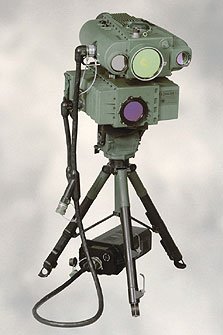
 The only thing I come up with, which is implausible, is that the webcam was visually scoped with a late gen. night optic, and then briefly designated, perhaps with an infrared laser.
Coincidentally, this could precisely pinpoint the device for GPS targeting purposes. (Just sayin'.)by Rob in SF 5/24/2011 10:43:49 AM @rob - except that the flash/pink pics (early eve) and the strange blue video (not long before dawn) were taken about 8 hours apart.by hudebnik 5/24/2011 10:49:19 AM
- @hudebnikby Rob in SF 5/24/2011 10:50:23 AM
- @hudebnik I'm discounting the blue video, just looks like auto-gain is out of whack...by Rob in SF 5/24/2011 10:51:01 AM
 Heat exchanger up for unit 2, in separate building? jen.jiji.comby bojack54 5/24/2011 10:52:01 AM
 @hudebnik @Rob in SF There is nothing mysterious about the change from blue to pink at dusk and the change from pink to blue at dawn. It is just the camera's IR cut filter. (see links below) But since the change is quite abrupt, as humans we are very likely to perceive an abrupt change as a flash.by jt 5/24/2011 10:52:22 AM
 this one very close:
QuakeAlert
DATE : 05/24/2011 12:18:16
TIME : 25 minutes ago
REG. : near the east coast of Honshu, Japan
MAG. : 4.6
DEP. : 34.8 km
ID : 112950
quakes.globalincidentmap.comby Edano 5/24/2011 10:52:32 AM- @bojack54 Baby-steps. Then:
" Meanwhile, Tokyo Electric Power continued preparatory work to strengthen the earthquake resistance of the lower part of the spent fuel pool of the No. 4 reactor, introducing radiation-shielding measures and setting up scaffolding.
The actual work will begin in mid-June and be completed by the end of July."
You start to get a sense of what a monumental task is ahead, and they're only working where they're able to...by Rob in SF 5/24/2011 10:54:19 AM - @jt @rob - I really don't know, I just reported what I observed (and I'm an experienced reporter with a lot of TV experience). The flash hasn't been reported before or happened since, tho the blue/pink changes have.by hudebnik 5/24/2011 10:59:11 AM
- @hudebnik blue/pink changes are just the day/night IR cut filter of the camera. They are not mysterious.by jt 5/24/2011 11:01:49 AM
- I don't disagree with that @jtby hudebnik 5/24/2011 11:02:56 AM
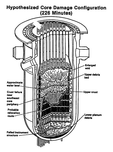
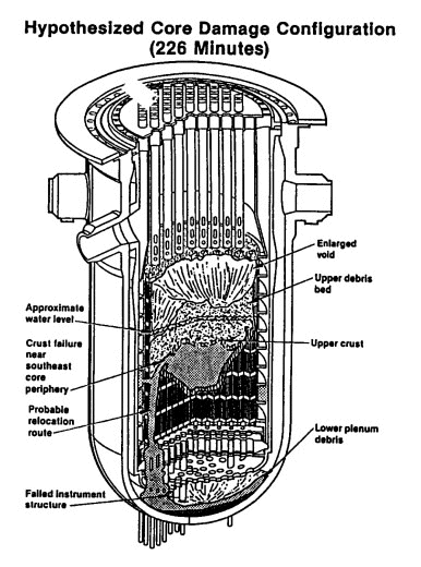
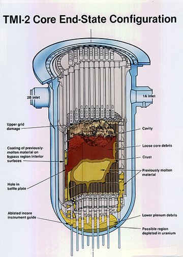
This is the TMI meltdown. I believe there was 20 tons (?!) of melted fuel in the "debris". I think dean worked on this. (Idaho National Laboratory)
www.inl.gov
www.inl.gov
www.inl.govby Rob in SF via Inl.gov 5/24/2011 11:09:50 AM- but the flashes aren't due to filter of the camera, aren't they? I'm no specialist, I understand that with the colours but can't imagine that filters cause flash.by Mina 5/24/2011 11:12:34 AM
- On TMI by the Smithsonian:
To some few experts, one piece of evidence strongly suggested that a considerable part of the fuel in fact lay in the bottom of the reactor vessel, where none should be. A few hours into the accident the neutron detectors toward the bottom of the inner wall of the cylindrical concrete shield surrounding the reactor vessel (solid black in Figure 2.6) began reporting anomalously large numbers of neutrons. As only the uranium fuel itself, not any of its highly radioactive fission products, could be a significant source of neutrons, the onset and continuance of such high readings from detectors in the vicinity of the bottom of the reactor vessel pointed to a “relocation” of a considerable part of the fuel. But as no one could imagine that a considerable part of the fuel had melted, there was no plausible explanation for how such a “relocation” could have taken place.
The “relocation” hypothesis was so much at variance with the tendency of nuclear power plant engineers and operators to take at every stage an overly optimistic view of the seriousness of the damage to the core, that relocation was not accepted until finally it could be seen by video cameras some six years after it had occurred. And even when seen and accepted as fact, the conclusion that it had poured down molten was not drawn.
americanhistory.si.eduby Rob in SF 5/24/2011 11:16:23 AM - @Mina If you watch a projection/video and it suddenly changes its light settings (colour), it can happen that this change is perceived as a flash before the brain realises it is the same image with changed colour. You can see this if you change the settings on a digital camera while looking at the same scene. No flash though. However with a projection/video, you are watching continuously, so the change is more abrupt when it happens.by jt 5/24/2011 11:16:45 AM
- @jt: thank you.by Mina 5/24/2011 11:18:57 AM
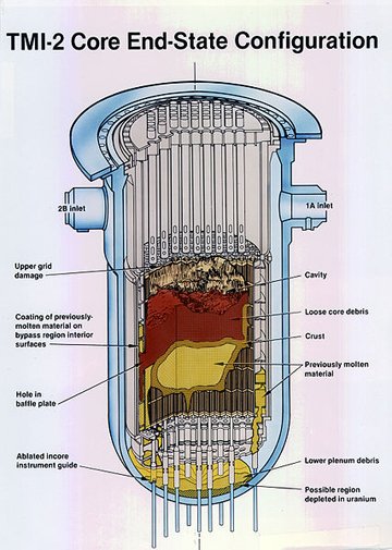
Mo' betta' graphic.
www.yardbird.comby Rob in SF via Yardbird 5/24/2011 11:28:26 AM heading for door but have noticed METI tweeting a lot havent seen anything we didnt know but I may be missing something.
twitter links don't work on scrib you need to copy paste the whole and it will take you to their profile with all their tweets
twitter.com!/METI_JPN
see you laterby elainekirk 5/24/2011 11:29:25 AM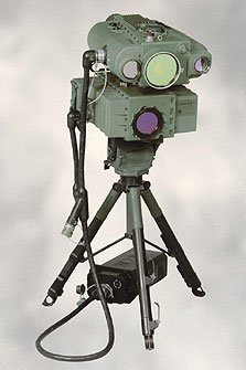
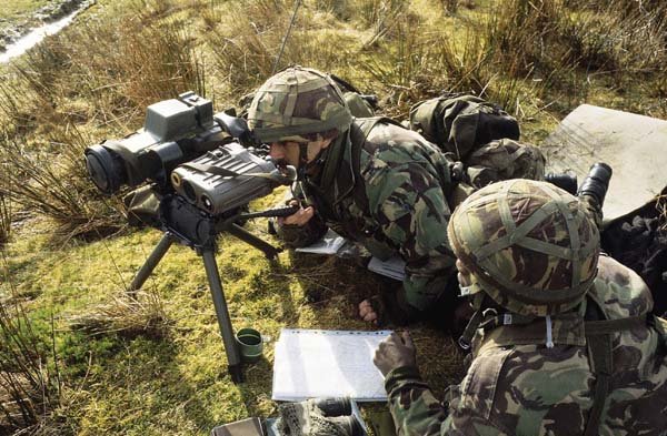
@hudebnik So here's the type of unit I was musing could have lit up the LiveCam...
img444.imageshack.usby Rob in SF via Img444.imageshack.us 5/24/2011 11:34:21 AM- @rob - ah I was thinking more of a sniper sight...by hudebnik 5/24/2011 11:35:49 AM
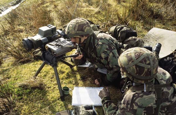
Would be good for the movie at any rate...
img517.imageshack.usby Rob in SF via Img517.imageshack.us 5/24/2011 11:36:02 AM- the Tepminator...?by hudebnik 5/24/2011 11:37:05 AM
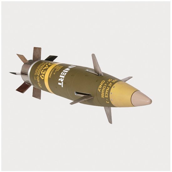
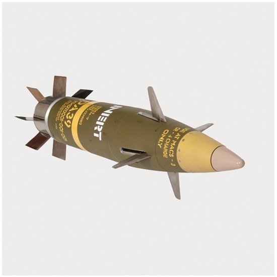
Nah, call in Excalibur rounds...
upload.wikimedia.orgby Rob in SF via Upload.wikimedia.org 5/24/2011 11:37:36 AM @hudebnik from a page back, 9.9...E-1 translates to 9.9x10to the -1 power.... that means as I recall .99 whatever the units are.by carabnr 5/24/2011 11:38:31 AM
- @hudebnik - Tepminator is almost impossible to say...
Tepminator Tonguetwister
Tepminator Tonguetwister
Tepminator Tonguetwisterby Rob in SF 5/24/2011 11:46:56 AM  @Rob in SF does the neutron emissions at TMI mean that those neutron beams detected early on at FUKU were a sign of the melt downs?by Nancy 5/24/2011 11:47:32 AM
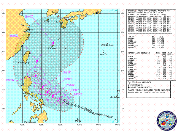
 Tropical Storm SONGDA: Current Data www.tropicalstormrisk.comby Majj 5/24/2011 11:49:10 AM
- @carabnr ty - so what would 2.01E+02 in the #1 drywell mean? Units Sv/hr originals here www.tepco.co.jpby hudebnik 5/24/2011 11:50:04 AM
- cnn main page www.cnn.comby Scilla 5/24/2011 11:51:50 AM
- Media waking up again at last!by hudebnik 5/24/2011 11:52:32 AM
- @Nancy - I had the same thought when I read that. Dean might know for sure. But they were detecting neutrons at the bottom of the RPV, where the fuel shouldn't be...
"As only the uranium fuel itself, not any of its highly radioactive fission products, could be a significant source of neutrons, the onset and continuance of such high readings from detectors in the vicinity of the bottom of the reactor vessel pointed to a “relocation” of a considerable part of the fuel." americanhistory.si.eduby Rob in SF 5/24/2011 11:52:44 AM - @Scilla @hudebnik That was my acid test, does CNN pick it back up.by Rob in SF 5/24/2011 11:53:56 AM
- The CNN article probably doesn't sound all that alarming to the avg person. No mention of all the contaminated basement water, dilemmas, ......... My coffee hasn't kicked in, buy you know...by Scilla 5/24/2011 11:56:16 AM
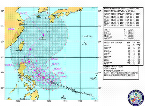
@Majj Yeah, Alblee pointed out that a typhoon is on the way earlier...
images.scribblelive.comby Rob in SF 5/24/2011 11:56:51 AM- buy = butby Scilla 5/24/2011 11:56:55 AM
- @Rob in SF I can't read the text, is that a pretty current path estimation?by Nancy 5/24/2011 12:05:46 PM
- @hudebink I think that means a shit ton for rads. 2.01E+02 Sv/hr in the #1 drywell 2.01 x 10 to the second power =201 sv/hr... lethal dose in 1 hour. Also extra info 100 rem=1 Sv.by carabnr 5/24/2011 12:06:20 PM
- Mata/laterby carabnr 5/24/2011 12:06:33 PM
- So those offficial Tepco figures CONFIRM 201 Sv/hr in the drywell of #1, as shown in the graphs posted a couple of pages ago.by hudebnik 5/24/2011 12:07:28 PM
- @Nancy Yup... Was by Alblee
Hi, all. Missed you guys. Just enough time online to post this...
Typhoon approaching the Philippines (currently at 55 knots over open sea).
Forecast to curve north and then northeastward into Japanese territory.
by Alblee via Usno.navy.mil at 12:52 AMby Rob in SF 5/24/2011 12:07:40 PM 
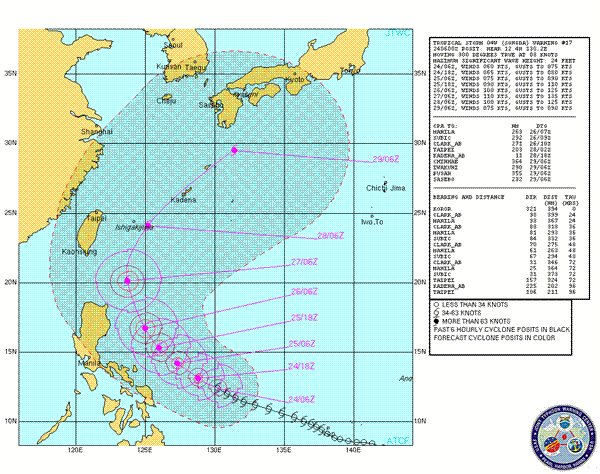
@All hi again! Tropical system 04W(Songda),
JTWC warning track- www.usno.navy.mil
JTWC Warning text- www.usno.navy.mil
JTWC have made no significant changes in their forecast. Currently models as mentioned by JTWC remain in close proximity when tracking the system, JTWC has amended their track map according to “known inaccuracies” in model forecasting when involving a recurve scenario as seen here (mentioned in prognostic reasoning). Models predominantly point to a Japanese mainland strike after crossing the Ryukyu Islands and Okinawa while the JTWC map reflects a close pass of the eastern coast line of Japan after crossing the Ryukyu Islands and Okinawa possibly as a CAT 3 system. Models also maintain the system intensity over mainland Japan to a certain extent, modeled winds range from 35-50kts extending most of the Japanese mainland. Currently the system sits in favorable conditions, the unfavorable shear profile is no longer present and deep flaring convection exists in the northern semi-circle, it will enter even more favorable conditions and rapid intensification is forecast as the system moves northerly past the Philippines land mass. A good envelope(area) of tropical air extends north to the Japanese mainland and present also is high sea surface temperatures extending north to southern Japan these conditions will aid the system in maintaining intensity as it moves further north in the later TAU’s(+72 hours). Something not mentioned by JTWC forecast unfortunately is precipitation, should the JTWC track map be indicative and correct of the situation then this will be much less of an issue, unfortunately if model forecasting is correct or close to correct and major land interaction with Japan occurs there is a forecast possibility of 100mm + over the areas of the Japanese mainland that come under the influence of the system. Currently any possible land interaction with Japan is over 100 hours away so the true scale of the event (if it occurs) can’t be said with certainty, however model consensus remains very tight in strength and track forecasts and there is little in the way of forecast conditions that may inhibit or prevent this system at least passing very closely by the Japanese mainland as a significant storm. Unfortunately land interaction is very possible as is the system arriving with significant intensity.by Thunder via Usno.navy.mil 5/24/2011 12:08:14 PM- That CNN artcle is gone from the main page now! It was just there in the latest news.by Scilla 5/24/2011 12:10:30 PM
- @Scilla They got the call.by Rob in SF 5/24/2011 12:11:07 PM
- Exactly.by Scilla 5/24/2011 12:11:32 PM
- It's still on the world tab, but, wow, it got yanked.by Scilla 5/24/2011 12:12:22 PM

Japan Earthquake | Page 1358
- Who's Blogging
-
 hudebnik
 alblee
 UKVal
UKVal Jonathan Keebler
 Oliver (ScribbleLive)
 kaykodh
 Markfm
 Angie
Angie Mid Valley
 Matt (ScribbleLive)
 George Gibb
- elainekirk
 PKelley
 lillymunster
 dean
dean bo
bo Edano
Edano Deb
Deb- Pedro Jesus
 IanGoddard