Japan Earthquake | Page 1442
 hi @ Peter... I noticed on a floor plan that there is one area (I'm not sure which side of building but I assume on the stack side) where there are air handling units prior to exiting the building... that's what I would say is the main building exhaust. Seems to me that the suppression pool vent would want to go through some sort of scrubber first..by dean 5/30/2011 2:26:05 PM
- fanaticcook.blogspot.com for Nancy and @all .. salmon routesby dean 5/30/2011 2:27:47 PM
- be back later... hope every one is having a good dayby dean 5/30/2011 2:30:08 PM
 Thanks dean!by Nancy 5/30/2011 2:30:22 PM
 @Nancy I don't plan on eating any Salmon or Crab coming from Alaska, (thinking about the King Crab now, knowing that many invertebrates are more susceptible to pollution than fish.) Anemones will shrivel and die, which will affect the clownfish. These two have a symbiotic relationship. If you lose one, you will lose the other. Snails and Nudibranch (sea slugs) won't do well either.by deb 5/30/2011 2:30:28 PM
- Bye Dean, have a great day too :)by deb 5/30/2011 2:30:48 PM
 @nancy the flooding maps are what the workers have been issued with !
As an important issue in the contaminated water Fukushima Daiichi nuclear power plant accident, JNN was created to call attention to workers in the field map "contaminated water" to get. High dose of water stop working, you can see piled up a lot of reality.
30 days, heavy rain also Fukushima. No smoking in the rain to see the buildings you will see the other side of the primary. According to TEPCO, which accumulated in reservoir water level throughout the morning on the premises 30 days, was called to see that the rise across the board.
"The (water) is greater than the rate of rise yesterday. Is not the influence of rain" (Press Office Hukuzima TEPCO Shortly after 9 am)
Is particularly worrying is the rise of the water is polluted water that contains high concentrations of radioactive material accumulated in the No. 2 and No. 3. Twice so far, have been found to have leaked out into the sea.
"Dari loaded with sandbags, and a blue seat cover, are doing to prevent the influx of rainwater" (press office Hukushima TEPCO Shortly after 9 am)
Contaminated water continue to grow. In addition to being injected into the leaking water reactor, has also increased water levels affect the ground water and rain.
Discourage large amounts of contaminated water for recovery, JNN is a summary for the distribution of workers in the field "pollution map" to obtain. Last week, "Kaname Shigeru isolation facility" which was posted, if you work around the water is said to have warned that always wear rubber boots.
The map focused on waste disposal from Unit 1 and Unit 6 has been described in detail so far have confirmed the situation. Unit 4 turbine building basement is completely blue. You can see that for almost submerged. Further.
[No. 1]
"More than 1000 mSv dose"
- Unit 3 turbine building;
"Red Water"
Unit 3 - building waste treatment;
"Where I can hear the sound of water flow can not be confirmed"
TEPCO 30, two employees of the 30s and 40s, to show that there is more than likely exposed to radiation dose limit of 250 mSv. The two men in charge of the No. 3 and No. 4, was referred to consult the work in the central control room before and after March 14 there was an explosion in the No. 3. (30 18:09)
news.tbs.co.jp
and it is radioactive and not from the rainby elainekirk 5/30/2011 2:31:05 PM- sorry didnt realise how long that translation wasby elainekirk 5/30/2011 2:32:23 PM
- @deb I mentioned a few weeks ago we could not find snow crab anywhere. That is something we can usually get at least as frozen seafood out here. We figured out that Sea of Japan is a major snow crab area and the other is off Alaska. So the guess was Japan exports are not happening for a number of reasons. Why the Alaska harvest that IIRC happens in January is suddenly gone seemed odd like either they stopped selling it from wholesalers or the harvest was small this year. I did read an article that there were overfishing issues in the Alaska crab areas. What I see happening is Woods Hole will gradually build data on the contamination flow and will announce when it is already far too late that we have contamination in multiple fishing areas in the Pacific.by Nancy 5/30/2011 2:55:49 PM
- Out for an hour or so :)by elainekirk 5/30/2011 2:57:25 PM
 Later All, Take care.by Shadow 5/30/2011 3:08:12 PM
 @Shadow Bye!by Angie 5/30/2011 3:08:32 PM
- Started thinking that I should heed my own advice, and sent an email to the radiation network about the map screen shots I have been posting on the tsunami site. I now have "official permission" to keep my history page! All he asked, was that the mineralab logo be in my shots, which I have been including, so all is good! This is the history page link: www.tsunamioftears.comby deb 5/30/2011 3:16:08 PM
Night everyone!by Angie 5/30/2011 3:20:20 PM
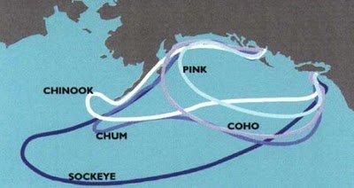
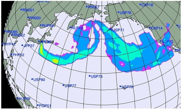
@dean Thanks for this. Here are the images from it for the page. I'm discovering that sometimes when images are being scrubbed from the web, the thumbnail Scribble makes for the page is the one remaining copy. Here are maps for comparison.
spreadsheets.google.com
1.bp.blogspot.comby radioguy via 1.bp.blogspot 5/30/2011 4:22:22 PM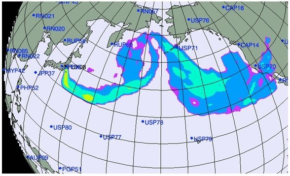 by radioguy via 3.bp.blogspot 5/30/2011 4:23:14 PM
 @radioguy Air or sea?by LM 5/30/2011 4:25:14 PM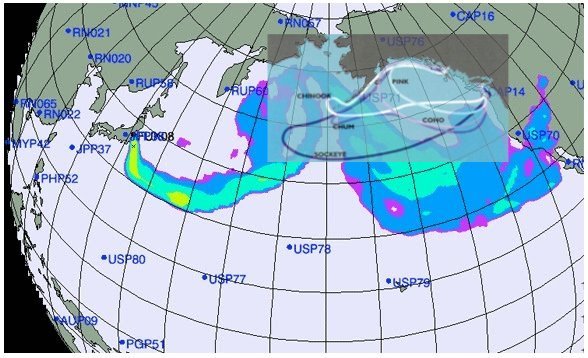
i55.tinypic.com
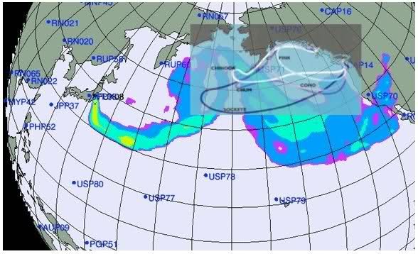
@LM This is compared to the original plume spread projections from March 16th, so it's aerial. If we can get se plume projections we can compare those too. I want more migratory routes. Here's the overlay.by radioguy via I55.tinypic 5/30/2011 4:30:41 PM- @radioguy Sorry...I'll assume air as the prior image mentions chinook winds. Wow..San Diego getting slammed. Yikes.by LM 5/30/2011 4:31:34 PM
- @Radioguy Thanks!by LM 5/30/2011 4:32:11 PM
- That projection was that first awful slam from the explosions.by radioguy 5/30/2011 4:32:33 PM
- The rotation on the overlay is off a bit but not enough to matter much.by radioguy 5/30/2011 4:33:33 PM
 @LM - that is Chinook salmon not winds.by Lethbridgean 5/30/2011 4:34:47 PM
- @Radioguy Unfortunately...The EPA monitor here in San Diego was offline until after March 23 or so. I suspect a little convenient!by LM 5/30/2011 4:34:51 PM
- @Leth Thanks! Not enough coffee this morning.by LM 5/30/2011 4:35:28 PM
- @LM It's OK... According to them ist's such a non-incident they're going to check on it again in 3 months... :rolleyes:by radioguy 5/30/2011 4:36:16 PM
- @Leth Duh...if I had noticed the sockeye..wow.I really am comatose this morning.by LM 5/30/2011 4:36:32 PM
- @LM - By chance are you from western Canada? As Chinook winds are only called that here. I live in Chinook country and invite the reprieve from old man winters grasp.by Lethbridgean 5/30/2011 4:40:41 PM
- @Leth No..I live in San Diego but grew up in the northeast...I remember growing up hearing about the chinook winds every time the cold winds would blow out of the north.by LM 5/30/2011 4:44:56 PM
- @LM -:)by Lethbridgean 5/30/2011 4:50:01 PM
 @radioguy Nice image. CTBTO has 60 monitoring stations - Each particulate monitoring station sends one γ-ray spectrum per day, a two-dimensional plot showing which radionuclides, and how much of each, occur in its sampling. Nuclear accidents produce a spectrum of radioactive fission products, including various radioisotopes of iodine, caesium and zirconium. The network can pick up all of them.
25th March the members of CTBTO agreed that this info should be for public. It was a lot of noise because it was not public (link) - ZAMG has made the animations from this info. But no one make these animations anymore, only for Japan – so where is now this information from CTBTO to be seen?
www.nature.comby Mona 5/30/2011 5:07:51 PM @Mona Germany appears to have stopped publishing the CTBTO data. That ought to tell you something.by Bobby1 5/30/2011 5:17:43 PM
- @radioguy That overlay paints an ugly picture. Also of concern to me, is the radiation found "on" the seabed. That means the sand, rock, and macro-life, where it won't be so easily dispersed or survived.by deb 5/30/2011 5:21:11 PM
- @Bobby it really bothers me-can you tell a bit more. The CTBTO info should be public, but where?by Mona 5/30/2011 5:22:15 PM
- @Bobby Can we find this out? I really want the truth to be known.by Mona 5/30/2011 5:23:50 PM
- @Mona There is no mandate that it be public. The only reliable data is coming out of Takasaki, Japan. Here is the German site: translate.google.com This is EURDEP radiation monitoring eurdep.jrc.ec.europa.euby Bobby1 5/30/2011 5:24:26 PM
Enhanced cooperation with other international organizations
Following an initiative by United Nations Secretary-General Ban Ki-moon, relevant international organizations have agreed to enhance cooperation to help mitigate the consequences of the nuclear disaster in Japan. These organizations include the CTBTO, the International Atomic Energy Agency (IAEA), the World Meteorological Organization (WMO), the UN Development Programme (UNDP), the World Health Organization (WHO) and the UN Office for Disarmament Affairs (UNODA), see press release of 25 March 2011.
Click for a regional dispersion simulation (Austrian Meteorological Service ZAMG)
The CTBTO contributes to this effort by providing information on the detection of radioactive isotopes from its worldwide monitoring network. The CTBTO can also assist in predicting the global dispersion of radioactive material by using its atmospheric transport modelling (ATM) tool which has been developed in cooperation with the WMO. This method allows for the calculation of the dispersion of a given radionuclide emission, using meteorological data. This calculation can be performed as back tracking in order to identify the area where a radionuclide may have been released, calculated from the station where it was observed. In the case of Fukushima, where the point of release was known, the CTBTO applied forward ATM to predict where radionuclides would travel in the future.
www.ctbto.orgby Mona 5/30/2011 5:26:52 PM- We haven't seen anything from Stockholm since its sudden cesium spike on May 7.by Bobby1 5/30/2011 5:29:59 PM
- @Bobby This says it shall be public. They got 2 stations in Japan area, 58 around the world. If this still is not public, then I don't understand. I shall look at the german site. But all countries, CTBTO says, get info every day and brief their governments and others. I want to see this info.by Mona 5/30/2011 5:31:42 PM
- "That info maybe can help us put pressure on *** gov to evacuate also.by Mona 5/30/2011 5:32:55 PM
- @Mona All the governments that have signed the test-ban treaty have all the data. But the treaty organization is not required to release this data to the general public, according to the treaty. We have 182 governments which have refused to release it.by Bobby1 5/30/2011 5:33:52 PM
 i can't find any real info on the Eurdep site either. Although it is clear that most countries are monitoring the map goes blank when you search for specificsby UKVal 5/30/2011 5:33:56 PM
- @UKVal It's a pretty horrible website. If you compare today to one year ago, it seems that radiation has increased, but the grid is too coarse to really tell. And of course, Chernobyl is still affecting the background.by Bobby1 5/30/2011 5:37:02 PM
- @Bobby1 true -it'sssssssssssssry slow to load & lots of data appears missingby UKVal 5/30/2011 5:38:44 PM
- whoops sorry -keyboard problems!by UKVal 5/30/2011 5:39:04 PM
Japan Earthquake | Page 1442
- Who's Blogging
-
 hudebnik
 alblee
 UKVal
UKVal Jonathan Keebler
 Oliver (ScribbleLive)
 kaykodh
 Markfm
- Angie
 Mid Valley
 Matt (ScribbleLive)
 George Gibb
- elainekirk
 PKelley
 lillymunster
- dean
 bo
bo Edano
Edano Deb
Deb Pedro Jesus
 IanGoddard