Japan Earthquake | Page 1948
 Looks like all the radiation in Japan went away. We can go home now. www.suntimes.comby Bobby1 7/17/2011 12:13:46 PM
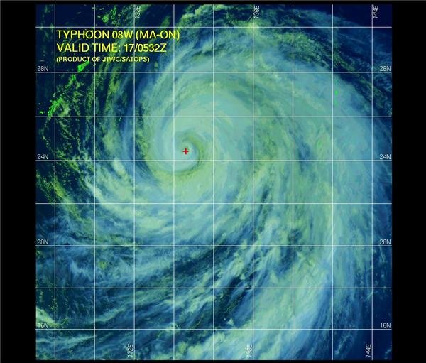
Good Morning for ALL Ma-on Becoming a Dangerous Storm
Jul 17, 2011 7:43 AM
As of Sunday morning, EDT, the center of Typhoon Ma-on was near 23.4 north and 135.6 east, or about 880 miles south-southwest of Tokyo, Japan. Movement was to the west-northwest at 11 mph. Maximum-sustained winds were over 125 mph with gusts to 155 mph.
Ma-on is currently over open water. The typhoon is expected to continue on a west to northwest direction over the next 24 hours, then start turning more northwest to north and eventually to the northeast. Some intensification will occur during this time and Ma-on could become a super typhoon.
As the storm turns more northerly, it will near southern Japan during the day on Tuesday, local time. Southern Japan will be on the lookout for strong winds, flooding rain and dangerous surf. The storm will track northeastward, then easterly south of Tokyo towards the middle of the week, bringing threatening conditions northward along the Honshu coast.
By AccuWeather.Com Meteorologist Eric Reese. www.usno.navy.milby Majj via Usno.navy.mil 7/17/2011 12:14:07 PM @Bobby1 that was tweeted by a number of journalists this morning under the banner
Prostitution Not Journalism
note at the end it says
Information for this article was gathered on a research trip subsidized in part by the Japanese National Tourism Organization and ANA.by elainekirk 7/17/2011 12:23:13 PM- @Majj thank you for the updateby elainekirk 7/17/2011 12:23:43 PM
- @elainekirk I'm glad somebody noticed that article was pure propaganda.by Bobby1 7/17/2011 12:24:59 PM
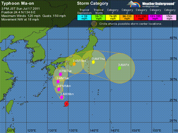
Model guidance in the extended Taus has remained very
consistent over the past 2 days in regards to the track and track
speeds. Due to the lack of a strong midlatitude shortwave trough and
westerlies, the re-curve is unusual in that the system will track at
relatively slow speeds (10-14 knots), maintain typhoon intensity
strength past tokyo; and lack significant baroclinic interaction
until it moves east of Tokyo. TY 08w is expected to complete extra-
tropical transition near tau 120. classic.wunderground.com icons-ecast.wunderground.comby Bobby1 via Icons-ecast.wunderground 7/17/2011 12:27:52 PM- tweet from happy
water from some of the shielding effect, I will be exposed to high dose radiation source is gone with it. It is not instantly killed and such dose浴Bitara dose while also removing water from a certain measure of 8000Sv / h in a piece of fuel.by elainekirk 7/17/2011 12:39:12 PM - by Majj 7/17/2011 12:39:41 PM
 Morning! - afternoon - evening!by lillymunster 7/17/2011 1:01:57 PM
- @lillymunster ooo you have some catching up to doby elainekirk 7/17/2011 1:02:36 PM
- High amounts of radioactive iodine in Tokyo sewage sludge proof Fukushima radiation emissions are continuing translate.google.comby Bobby1 7/17/2011 1:04:50 PM
- twitpic.com
this is mulch being sold in garden centresby elainekirk 7/17/2011 1:08:18 PM - They make me sick only by this NEWS : Crippled Nuclear Plant Meets Three-MonthGoals. Armed with unmanned robots and foreign technology, workers have been able to prevent further meltdowns and explosions at Japan's Fukushima Daiichi nuclear plant, and largely met the three-month goals laid out in the roadmap for bringing the plant to a safe condition.
The nine-month roadmap, announced on April 17, was plant operator Tokyo Electric Power Co.'s answer to criticism that its response to the crisis was too ad hoc. The plan's first-stage goals were to achieve stable cooling of the heavily damaged reactor cores, secure storage space for the highly radioactive water and prepare countermeasures against any new quakes or tsunami.
A trial fitting last month of a cover for Fukushima Daiichi's Unit 1 No. 1, meant to limit the release of radioactive material
"Most of the objectives have been accomplished," Japanese Prime Minister Naoto Kan declared Saturday when he visited local leaders. online.wsj.com . Lets Forget Fukushima , it is every thing Ok there. may be we study "Cloud Formations".....by Majj 7/17/2011 1:09:04 PM - I have my browser stuffed with links from last night. Today's news roundup should be long. Most are too good to drop.by lillymunster 7/17/2011 1:10:31 PM
- @lillymunster really good @smoss and @ralph found further llinks after you went to bedby elainekirk 7/17/2011 1:12:24 PM
- The asahi article about hamaoka was more detail about the sea water leaking in through the condenser. The end cap was leaking or failed as were piping. Sounds more than the initial holes in the condenser. They went cheap during original construction. 5 is newer and was likely one of those units where in country companies had a greater hand in design & construction.by lillymunster 7/17/2011 1:14:36 PM
- Some of the links from last night probably deserve their own article. I think we need to put together the facts on what a farce the cold shutdown is and why trying to shove people back to the exclusion zone is too.by lillymunster 7/17/2011 1:18:41 PM
- @lillymunster it is national holiday tomoro in Japan Steve Herman just tweeted that goj are going to ban cattle shipments from fuku ....on tuesday !!! you couldnt make it upby elainekirk 7/17/2011 1:21:00 PM
- @elainekirk this has to really be angering people who live in Japan. It isn't like people can just not eat. What gets me is that they say eating beef that is contaminated once is no big deal. But people eat usually 3 times a day every day. So if many things in the food supply are contaminated it is a huge deal even low levels.by lillymunster 7/17/2011 1:29:24 PM
- @lillymunster The problem will be an order of magnitude worse after the autumn harvest.by Bobby1 7/17/2011 1:33:15 PM
- @Bobby1 I know. They have got to get a grasp on it and in an honest way. This BS that keeps trying to downplay and ignore the risks can't keep happening.by lillymunster 7/17/2011 1:36:22 PM
- @lillymunster the people are fighting but it really needs people to keep pushing for them internationally and I am wondering if it would be good for you to give rockhopper a really good plug get people following him I copied his translations of a workers tweets further down and I think if people followed him on twitter they would become more aware of the real situation at tepco he only has 70 followers it needs to be at least 7000by elainekirk 7/17/2011 1:37:29 PM
- I am out now for awhile catch up with you all later
by elainekirk 7/17/2011 1:38:12 PM  Stress tests on reactors to look at four disaster scenarios [17 July, 2011]: www.asahi.com
"Nuclear power companies will be required to prove their reactors' ability to withstand four disaster scenarios under new "stress tests" outlined by Japan's Nuclear and Industrial Safety Agency (NISA).
The tests, detailed in a report submitted by NISA to the Nuclear Safety Commission of Japan (NSC) on July 15, will require power companies to model their nuclear power stations' endurance in a major earthquake, a tsunami, a complete loss of power throughout a plant, and a loss of ability to release heat from the reactors."by es 7/17/2011 1:39:54 PM- One of the workers talking about craving Haagen Daaz. :-)by lillymunster 7/17/2011 1:40:19 PM
- Volunteering trip transforms view of disaster: Profound weekend in Tohoku casts new light on tragedy's true scale [17 July, 2011]: www.yomiuri.co.jpby es 7/17/2011 1:42:59 PM
- Fukushima cattle shipments banned - Cesium in beef, straw prompts closer scrutiny [16 July, 2011]: search.japantimes.co.jp
"The government's nuclear disaster task force said Friday that shipments of beef cattle from Fukushima Prefecture will be suspended, amid concern that cows from there may be contaminated with radioactive cesium.
The Fukushima Prefectural Government has already begun inspecting all local beef cattle farms and requested they voluntarily refrain from shipping cows until at least next Monday when the inspections are to be concluded.
The central government reached its own decision regarding beef cattle shipments from Fukushima after consulting with prefectural authorities, government sources said."by es 7/17/2011 1:50:56 PM - Chris Busby's talk in Japan www.ustream.tv
Shukan Gendai (Japanese weekly magazine) sent (I think) the air filters of the cars from Japan, one from Fukushima, the other from Tokyo. From the air filter from Fukushima, plutonium-239 was detected. From the air filter from Tokyo, uranium-235, tellurium-129. ex-skf.blogspot.comby Bobby1 7/17/2011 1:54:05 PM - @es, you had me thinking the other day. I think I could easily set up a solar panel & battery to charge our laptops in the living room. :-)by lillymunster 7/17/2011 1:59:38 PM
- @lillymunster Great! Even if it slowly trickle-charges the battery every little helps, and it's all free! :o)by es 7/17/2011 2:12:09 PM
 Did anyone read the links I posted about MOX fuel last night? One NISA document and one report from the JAERI conference from 1996. translate.googleusercontent.com www-nds.iaea.orgby Ralph Unger 7/17/2011 2:12:13 PM
- @Ralph Unger I grabbed and saved the links. Have not read yet. What is your take on what Smoss found?by lillymunster 7/17/2011 2:19:18 PM
- "Of this material can not be exposed because the contents of the boxed belong to secret" explains the blank parts of the document under discussion yesterday." What did Smoss find exactly? I just found out that MOX is indeed much more volatile then reg fuel.by Ralph Unger 7/17/2011 2:24:30 PM
- Even when being stored.by Ralph Unger 7/17/2011 2:24:58 PM
- @Ralph Unger what do you think was in the blocked section of that first document? It seemed like some sort of reading but the 1-4 really threw me. It seemed like an odd categorization if they were showing isotopes or chemistry or something.by lillymunster 7/17/2011 2:26:08 PM
- It is in my post, the second link.by Ralph Unger 7/17/2011 2:27:13 PM
- Only the first paper is relevant to MOX. "Isotopic Analyses and Calculation by Use of JENDL-3.2
for High Burn-up U 02 and MOX Spent Fuels "by Ralph Unger 7/17/2011 2:32:10 PM - Everyone seems focused on the news, but this accident is not news. it is history that started in the 1950's. To understand it, old documents need to be considered. And never trust a bad machine translation of a document written in Japanese. Try to find the document in English or it's equivalent.by Ralph Unger 7/17/2011 2:45:22 PM
- Key players got nuclear ball rolling search.japantimes.co.jpby Ralph Unger 7/17/2011 2:48:02 PM
- @Ralph Unger there is some continuity to the translations, you just need to understand how the translations commonly work. The area I would still consider possibly unreliable is in number factors. Those have been known to convert wrong such as the hole in #2 moving a decimal point and making a smaller hole convert to the size of a house. :-)
Most translations have been accurate and understandable as long as you understand the phraseology and what odd words like "hospital" actually mean to the translation. All this really makes me want to learn Japanese.by lillymunster 7/17/2011 2:53:32 PM 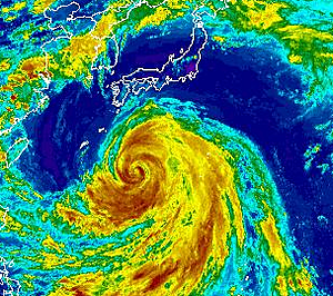
Powerful Typhoon Ma-On Targeting Japan
By Dave Samuhel, Senior Meteorologist
Jul 17, 2011; 5:57 AM ET
vortex.accuweather.com Typhoon Ma-On, now packing the strength of a Category 3 hurricane, continues to threaten Japan.
Landfall in southern Japan is a distinct possibility as early as Monday night local time and recent data is even more threatening.
Winds in Ma-On strengthened from 105 mph to 135 mph on Friday before weakening slightly. The storm has since re-strengthened slightly today and further intensification is expected as it passes across the extremely warm waters of the Philippine Sea.
Ma-On will reach its peak intensity later this weekend, and it may become a super typhoon with sustained winds near 150 mph range.
Although not expected to be in the direct path, U.S. military bases in Okinawa will likely have strong winds and heavy rainfall this weekend from the outer bands of Ma-On.
The storm will continue to turn more northerly for the rest of today and Monday. The earlier the turn to the north occurs, the better chance Ma-On will miss a direct landfall on southern Japan.
However, the most likely track at this time takes Ma-On into the Kyushu or Shikoku islands in southern Japan early next week. As mentioned above, recent data shows that this re-curve will occur even slower and that is why we think the threat to Japan is increasing.
Widespread adverse impacts from rain, wind and heavy seas would result from a direct hit on the southern mainland. Heavy rain, high winds and rough seas could also impact the site of the tsunami and nuclear disaster north of Tokyo.
Storms of the kind that Ma-On is likely to become can unload extreme rainfall of 10 to 20 inches, with flooding and mudslides, upon reaching Japan.
Greater Tokyo is unlikely to feel the worst of the storm, no matter its ultimate track. Still, flooding rain and damaging winds could hit at midweek or a day before. However, there is enough uncertainty in the track of Ma-On that we cannot say that a direct hit is not possibleby Majj via Vortex.accuweather 7/17/2011 2:58:05 PM- "Me beat you" and "You beat me" are not reliable in a Japanese machine translation so it is pretty useless.It will only lead to much speculation over irrelevant things like the high readings of radiation that I discovered was actually feedwater nozzle volume misread from a chart a few weeks ago.by Ralph Unger 7/17/2011 2:59:27 PM
- I'm not a conspiracy believer but I find estrange that I find very fell NEWS on Typhoon Ma-On . This is a very big storm , going direct to a very populate area. There shod be many news talking on it , but there are NO. Every thin I find on Google search is average 12/16 hours old. Very Oddby Majj 7/17/2011 3:05:47 PM
- @Ralph Unger If you read things in context it can be determined. It is more of an art than a science. Some translate well, others not so much.by lillymunster 7/17/2011 3:10:34 PM
- If you live in the US it is not odd, our news does not cover much more then the US.by Ralph Unger 7/17/2011 3:10:50 PM


Japan Earthquake | Page 1948
- Who's Blogging
-
 hudebnik
 alblee
 UKVal
UKVal Oliver (ScribbleLive)
 Jonathan Keebler
 kaykodh
 PKelley
 Markfm
 Angie
Angie Deb
Deb Mid Valley
- Pedro Jesus
 Matt (ScribbleLive)
 George Gibb
- elainekirk
- lillymunster
 dean
dean bo
bo Edano
Edano IanGoddard