Japan Earthquake | Page 1062
 @Tenzing i will probably make it a formatted bi-lingual document and make it public. I can send email notifications once I have it done. :-)
by Nancy 5/9/2011 12:37:24 PM- Since there are more people on this morning I'm reposting a question from last night. Does anyone have any evidence or opinions on possible earthquake damage to the reactors. Thoughts on what would be damaged, factors that would cause that, what would be damaged?by Nancy 5/9/2011 12:39:54 PM
- does anyone know if there are any reactor stats from the SCRAM? Looking for data for that hour between the EQ and the tsunamiby Nancy 5/9/2011 12:40:32 PM
 @Nancy Could you maybe get @Thunder out of mod please? He has the update on the weather.by Angie 5/9/2011 12:40:38 PM
- @Angie will do!by Nancy 5/9/2011 12:40:52 PM
- @Nancy Thanks!by Angie 5/9/2011 12:41:15 PM

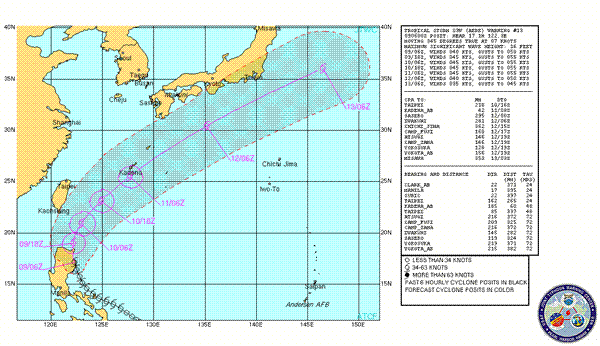
Tropical Storm 03W (Aere) Warning #13
Issued at 09/0900Z
Warning graphic- www.usno.navy.mil
Sat image-(available @JTWC)
Warning text- www.usno.navy.mil
Prognostic reasoning- www.usno.navy.mil
My assessment…..Ok, the system unfortunately(from the Japan perspective) made a faster move northward through the last 18-20 hours, this is different to what I proposed would happen yesterday, the Steering winds arrived with a greater force than forecast, this pushed the system more northerly and hence the land interaction with Northern Luzon, Philippines has been limited, it has however still weakened the system slightly but it will likely rebound in the short term due to favorable sea surface temps, atmospheric moisture and upper conditions(pole ward out flow and low shear), once the system enters the Luzon strait it is forecast to have favorable conditions to continue at tropical storm strength(see JTWC), there is however as per current prognostic sources(CMISS @ 11:30 UTC. Water vapor/shear tendencies) and my reasoning the ability for the system to intensify even more than forecast by JTWC, this development will not be significant and will be relatively short lived as the system moves further north into less favorable conditions around the area of Taiwan, it will/could however have an effect on the final strength of this system if it were to make it to Japan. The track taken by the system is in my mind still relatively uncertain in the later time frame (36 hours plus from 11:30 UTC), models show a more westerly track ending in dissipation just south of the southern tip of Japan crossing over Okinawa (see earlier track map by @Alblee), JTWC have revised this forecast by including “known inaccuracies” to produce a slightly more easterly track. IMO the system in the later TAU’s will be dominated by the effects it undergoes in the Luzon strait. Currently these vary depending on whether the forecast/models are true and correct, should the shear tendencies become even more favorable (currently decreasing in strength) and it continues to obtain a good in-flow of water vapor from the tropical areas(which it is), the system will be stronger on extra tropical transition and could potentially have the ability to reach the Japanese mainland with potential gale force winds of 35-40kts+(worst case, not highly likely). However the system seems to be slowing as the steering winds seem to be decreasing in strength (my assessment-could be wrong), if the system slows too much it will be met by more unfavorable conditions for development in the Luzon strait and less favorable steering conditions to make landfall on Japan, the system could be blocked and dissipate before reaching Taiwan or travel much further east away from Japan. The steering winds however are forecast to increase again and be more westerly in their orientation, if they are stronger than forecast this would also produce a more easterly track away from Japan but at current forecast strength the JTWC track doesn’t seem unreasonable. To summarize….it’s VERY uncertain at the moment what, if any effect the system may have on Japan, the picture will be much more clearer when the system enters the Luzon strait in 9-12 hours, I will be back in around 24 hours to see what Aere is doing and give another assessment, I should have a much better idea of things then and to add one thing, it [should] not reach the Japanese mainland with enough force to be of great concern. BTW…I am no meteorologist and the next warning will be out in about 3 hours….or 1500 UTC!:-)by Thunder via Usno.navy.mil 5/9/2011 12:41:29 PM @dean Hi dean, how goes it?by Jim 5/9/2011 12:43:14 PM
- @Jim, have some geology questions if you have time.by Nancy 5/9/2011 12:46:32 PM
- Live and not-so-live Camera Feeds at www.gloresis.infoby Jim 5/9/2011 12:47:40 PM
- @Nancy K, Nancy, I'll try..and could a mod put that on my pin thing?by Jim 5/9/2011 12:48:42 PM
- If I don't know the answer, I'll research it.by Jim 5/9/2011 12:49:49 PM
- MIT article on ongoing chain reactions at FUKU www.technologyreview.comby Nancy 5/9/2011 12:52:56 PM
- @Jim scribble is not letting me edit pins for some reason. Will try it again later.by Nancy 5/9/2011 12:55:47 PM
- @Jim, My geology type question was with the site and the way the plants are sort of floating on the mudstone layer with the potential for groundwater to "float" the buildings. Does this situation possibly amplify the earthquake. If it does is it lateral, vertical or a combination?by Nancy 5/9/2011 12:57:41 PM
 Fission Products in Seattle Reveal Clues about Japan Nuclear Disaster
The first analysis of nuclear fission products in the atmosphere over Seattle provides a unique insight into the nature of the disaster. "When the Fukushima nuclear disaster began to unfold after the 11 March earthquake and tsunami, it quickly became clear that anything downwind was in for a sprinkling of radioactivity. So Jonathan Diaz Leon and pals at the University of Washington in Seattle were ready.
These guys began removing air filters from the intake to the ventilation system of the Physics and Astronomy building at the University of Washington and then measuring the levels of radiation they were emitting. Initially, the filters contained nothing out of the ordinary. Then, sometime between 12pm on 17 March and 2pm on 18 March, the radiation levels began to rise.
By measuring the energy of the gamma rays from the filters, these guys have identified exactly which fission products have made their way across the Pacific. And this in turn allows them to make a number of interesting inferences about what has gone wrong at Fukushima. Today, they post the results of the first five days of monitoring on the arXiv.
What they found was small amounts of iodine-131, iodine-132, tellurium-132, iodine-133, cesium-134 and cesium 137.
First things first: the levels of all of these substances were all well below the limits set by the US Environmental Protection Agency. The levels of iodine-131, for example, were at least 100 times lower than the EPA's limit. "We note that the observed radioactivity levels are well below alarming limits at our location," say Diaz Leon and buddies.
Having got that out of the way, they draw a number of interesting conclusions from the data.
The first comes from the amount of iodine-131 and tellurium-132 which are both short-lived with half lives of 8 and 3 days respectively. That indicates that they must have come from fuel rods that were recently active rather than from spent fuel. www.technologyreview.comby Tenzing 5/9/2011 1:00:32 PM doing well Jim...by dean 5/9/2011 1:01:42 PM
 @hudebnik TY for that link to 648 mSv/hr. Understand and also @Ralph Unger, that the level varies down to 10 mSv/hr. These levels inside the R1 building are not low, but work can be managed with proper planning. R! seems to be proceeding as planned with TEPCO. I hope for all possible progress and they seem to be working it well. Human entry to the building was just the first step.by RBeaner 5/9/2011 1:02:46 PM
- The Long-Term Impact of Fukushima
Experts look ahead in a series of articles published today by the journal Nature.
By Kevin Bullis
The journal Nature is publishing several articles today looking at the long term impact of the nuclear disaster at Fukushima in Japan. They're all available to the public.
One news report considers what it will take to fully decommission the damaged plant, a process that could take more than a decade,
After the tsunami on 11 March knocked out backup generators — preventing cooling water from circulating around the hot cores of reactors 1-3 — the fuel rods inside began to warp, split and at least partially melt. Steam reacted with the rods' outer sheath of zirconium, creating hydrogen gas that caused a sequence of massive explosions (see Nature 471, 417-418; 2011). But data from Japanese regulators and TEPCO suggest to some researchers that conditions inside the core could be far worse than a partial meltdown. Some believe that molten fuel may have flowed into the outer concrete containment vessel, whereas others suggest that nuclear chain reactions are still happening inside the fuel. my.technologyreview.comby Tenzing 5/9/2011 1:03:12 PM - Nancy, maybe a good starting point on the first hour would be to go through what is done at a commercial plant when they receive a seismic trip, ie: they have standard recovery procedures if they get a scram that way which must be followed. so lets try to search for that.. and, in addition a scram recovery procedureby dean 5/9/2011 1:03:59 PM
- @Nancy remember, they kept the groundwater pumped down significantly, until the earthquake hit and they had to go to emergency power. Groundwater "may" have been a factor in aftershocks(probably was) but not during the big one.by RBeaner 5/9/2011 1:06:01 PM
- @dean any idea what that document would be called? Marie found a document that has some movement factors that were recorded in the building basements. That shows movement in a "gal" expression of centimeters.by Nancy 5/9/2011 1:06:10 PM
- I'm quite sure that with that EQ which wasn't your normal seismic event, that they would have been thinking of scram recovery due to the damage sustained and perhaps damage they were not even aware of at the moments after it occured.by dean 5/9/2011 1:07:06 PM
- @Nancy I could have written that MIT article myself and others on the forum have said the same thing. Is it actually floating on a mudstone layer? I need to do a little research concerning the stratigraphy of the local area to see the stratum in which we are dealing. The assumption is that the builders dug down to stable ground during construction. However with the frequency of tremors in that area, it is not inconcievable that what was once sound footings, may have deteriorated over time.by Jim 5/9/2011 1:07:07 PM
- @Jim these are articles I gleaned off the scribble page on the soil and build of the plant related to soil mudstone
www.iitk.ac.in
bedrock 46 meters below
mdn.mainichi.jp
bouyancy and groundwater
www.asahi.comby Nancy 5/9/2011 1:08:17 PM - @Jim At TEPCO presser they state excavated entire site and built on bedrock, then here they picture it. But here they describe it differently as a mudstone (indurated shale) at ~17 meters, not the 46 meter bedrock.by RBeaner 5/9/2011 1:09:31 PM
- @Nancy K, I'll have a look and get back with a report.by Jim 5/9/2011 1:09:43 PM
- The main question that was posed to me is, did the initial EQ cause damage to the reactors? How can we indicated that it did? Workers are the plants are telling that there was, TEPCO is claiming not.by Nancy 5/9/2011 1:10:01 PM
- I posted a copy of a Technical Safety Requirements document some time ago and in it there are the parameters for all plant systems and typically what happens is, when a parameter goes out of specs it forces the plant into a LCO, AND identifies the actions necessary to recoverby dean 5/9/2011 1:10:04 PM
- @Jim thanks, that would be a huge help.by Nancy 5/9/2011 1:10:25 PM
- @dean are they also required to record things like pressure and temps right after a scram? Wondering if there might be some tell tale info like a pressure loss or crazy obviously wrong reading indicating a damaged sensor etc?by Nancy 5/9/2011 1:11:38 PM
- @dean any idea how to search for that document to back track it?by Nancy 5/9/2011 1:12:24 PM
- Nancy, all systems at nuc facilities are broken down to those required for safety (SSE), then those important to safety and the seismic requirements are different for the lower graded systems and those lower graded systems are most susceptible to damageby dean 5/9/2011 1:12:53 PM
- indeed Nancy,, they would have monitors, and what we really need are the computer saved data... and from what I've read of the weeks, the plant was not responding to a typical scram,by dean 5/9/2011 1:14:55 PM
- Chain Reactions Reignited At Fukushima After Tsunami, Says New Study
Radioactive byproducts indicate that nuclear chain reactions must have been burning at the damaged nuclear reactors long after the disaster unfolded KFC 05/09/2011
"Today, Tetsuo Matsui at the University of Tokyo, says the limited data from Fukushima indicates that nuclear chain reactions must have reignited at Fuksuhima up to 12 days after the accident.
Matsui says the evidence comes from measurements of the ratio of cesium-137 and iodine-131 at several points around the facility and in the seawater nearby. He has calculated what the starting ratio must have been by assuming the reactors had been operating for between 7 and 12 months.
He says the ratios from drains at reactors 1 and 3 at Fukushima are consistent with the nuclear reactions having terminated at the time of the earthquake.
However, the data from the drain near reactor 2 and from the cooling pond at reactor 4, where spent fuel rods are stored, indicate that the reactions must have been burning much later.
"The data of the water samples from the unit-4 cooling pool and from the sub-drain near the unit-2 reactor show anomaly which may indicate, if they are correct, that some of these fission products were produced by chain nuclear reactions reignited after the earthquake," he says.
These chain reactions must have occurred a significant time after the accident. "It would be difficult to understand the observed anomaly near the unit-2 reactor without assuming that a significant amount of fission products were produced at least 10 - 15 days after X-day," says Matsui. www.technologyreview.comby Tenzing 5/9/2011 1:15:06 PM - I will try to search up some documents that will help to determine a normal scram, and recovery procedures for a normal scram and seismic scram @ Nancy.. do you have the technical Safety Requirements document...by dean 5/9/2011 1:15:48 PM
- @Nancy According to "all evidence", I have seen nothing to controvert this, The reactors scrammed exactly as they were supposed to when the EQ detectectors in the plant tripped at the first sign of the 3/11 EQ. All evidence I have seen says that the batteries and then the generaters and cooling system performed exactly as planned for ~45 min. Meaning no sig damage....All until the Tsunamki whacked them. I see no evidence, whatsoever, of Significant innitial earthquake damage to the plant and cooling system. Anyone else have any Data/evidence otherwise?????by RBeaner 5/9/2011 1:16:33 PM
 @Tenzing Still happening, Tenzingby Bobby1 5/9/2011 1:17:11 PM
- I believe that the pressure did not respond correctly because the relief valves stuck for starters... then actions that normally should occur. like on interlocks for the systems did not all workby dean 5/9/2011 1:17:30 PM
- @dean don't have the Tech Safety doc. per your second post, yes those are the kinds of things I am looking for, stuck valves, things that did not respond, pressure levels that were not in range during that hour between scram and the tsunami.by Nancy 5/9/2011 1:19:08 PM
- @RBeaner If that's true, that would not be a goog thing. While shale might be considered bedrock, that's a poor foundation. "Shale" is kind of a 'catch all' term that could be a siltsone or mudstone with possibly varying degrees of metamorphism. I will check. Japan has top notch geologists and this has been researched.by Jim 5/9/2011 1:19:14 PM
- @dean For a typical scram, the relief valves would not trip, and what interlocks? My understanding, from the information actually released (caveat) is that it was fine till tsunami. Not to be argumentative, but alot of baseless speculation as info dries up, around here. Is there DATA that supports improper scram at the onset?by RBeaner 5/9/2011 1:20:45 PM
- @dean, is that technical safety document written unique to each NPP or is there a generic one used for all of that model of reactor?by Nancy 5/9/2011 1:21:07 PM
- RBeaner, I will have to look for a video where they discussed the early part of the scram and how data was missing but how quickly the deterioration of the plant to the point of meltingby dean 5/9/2011 1:21:32 PM
- @RBeaner that is the crux. TEPCO is releasing info saying everything was peachy until the tsunami. Some of the technicians at the plant are telling otherwise.by Nancy 5/9/2011 1:21:57 PM

Japan Earthquake | Page 1062
- Who's Blogging
-
 hudebnik
 alblee
 UKVal
UKVal Jonathan Keebler
 Oliver (ScribbleLive)
 kaykodh
 Markfm
 Angie
Angie Mid Valley
 Matt (ScribbleLive)
 George Gibb
 elainekirk
 PKelley
 lillymunster
 dean
dean bo
bo Edano
Edano Deb
Deb Pedro Jesus
 IanGoddard