Japan Earthquake | Page 1397
 Greenpeace says it proves radioactivity is accumulating in marine life and not diluting, as claimed by Japanese authorities. www.abc.net.auby deb 5/27/2011 6:22:50 AM
 The Bloomerg article that Majj posted can really get your blood boiling. For instance:
“Tepco knows more than they’ve said about the amount of radiation leaking from the plant,” Jan van de Putte, a specialist in radiation safety trained at the Technical University of Delft in the Netherlands, said yesterday in Tokyo. “What we need is a full disclosure, a full inventory of radiation released including the exact isotopes.”
The government plans to release details on the radiation released at the “appropriate time,” said Goshi Hosono, an adviser to Prime Minister Naoto Kan who is overseeing the crisis response and appears at daily briefings at Tepco’s headquarters.
<...>
(T)he company has failed to disclose the scale of radiation leaks and faces a “massive problem” with contaminated water.
<...>
By May 18, almost 100,000 tons of radioactive water had leaked into basements and other areas of the Fukushima Dai-Ichi plant, according to Tepco’s estimates. The radiated water may double by the end of December.
www.bloomberg.com
It's as if all this water is surprising them.by Rob in SF 5/27/2011 6:29:37 AM- Arggggh!
There simply has to be cracks in the basements and tunnels allowing this highly radioactive water to seep into the groundwater and ocean. It is beyond me why they haven't bought a double-hull tanker that can hold 100,000 tons+ of this waste-water. They're not going to filter it all, who are they kidding? They're still trying to see how inexpensively they can get through this fiasco?!!!
It's well past time to start playing hard-ball with these clowns, and hopefully there's still time before they really screw the pooch.
This could be the end of the Pacific fisheries forever, and that could mean turn out the lights.by Rob in SF 5/27/2011 6:53:54 AM WIPP it good.
by Rob in SF 5/27/2011 7:17:25 AM I can scoop up ground, soil, contamination as they are doing in the Fukushima schoolyards, but if it gets into the groundwater? That was the major concern at Chernobyl, and it has already happened here.by Ralph Unger 5/27/2011 7:18:52 AM
 Can someone check the U3 Temp labels I put in here and see if they're right? houseoffoust.comby radioguy 5/27/2011 7:23:11 AM
- (I'll leave that. Bed time here. Just comment on the page if I got any wrong.)by radioguy 5/27/2011 7:26:39 AM
- So long and thanks for all the fish.by radioguy 5/27/2011 7:27:33 AM
 I look and they look fine to me..............But I am very far from Techi! You are doing a great job btw!by Angie 5/27/2011 7:34:55 AM
 Nice video compilation of Unit 3 photos : www.youtube.comby Ian 5/27/2011 8:00:51 AM
 @radioguy ... Aww, Hitchhiker. Goodnight and good job! :)by ms in la 5/27/2011 8:03:25 AM
 Morning @allby hudebnik 5/27/2011 8:23:32 AM
- One thing that has struck me before and is shown well in the vid posted below by @ian is how the concrete seems to have powdered away from the rebar in the explosions. I wonder how high the quality of the concrete was and thus how easily cracked the containments and basements were.by hudebnik 5/27/2011 8:26:55 AM
- @hudebnik - EQ forces on the concrete foundation/tunnel work vs explosion forces on the concrete curtain walls may make any such conclusions a stretch.by Rob in SF 5/27/2011 8:35:17 AM
- Hi @rob - indeed. Maybe among the many talents on the board we have a building expert.by hudebnik 5/27/2011 8:37:42 AM
- Cabinet's nuclear safety chief totally confused after TEPCO reversal on water injection
Nuclear Safety Commission Chairman Haruki Madarame. (Mainichi)The head of the Cabinet Office's Nuclear Safety Commission is at a loss following Tokyo Electric Power Co. (TEPCO)'s sudden denial that a seawater injection operation to cool an overheating reactor at the Fukushima No. 1 Nuclear Power Plant was ever stopped.
"My head is full of question marks. I'm totally confused now," Haruki Madarame told reporters on May 26.
TEPCO had claimed that the injection operation to cool the Fukushima plant's No. 1 reactor was halted by a government order before reversing itself on May 26. Madarame's name had been attached to the supposed halt order due to comments he allegedly made on March 12 warning the operation could reignite nuclear reactions in the core. The comments were included in news conference materials used by the joint government-TEPCO nuclear crisis response office.
Madarame consistently denied any connection to a halt order, and the crisis response office later amended his comments to read, "A return to criticality cannot be ruled out."
"Right now, all I want is someone to tell me what is really going on," Madarame said. "So the operation was never halted. So how did I get dragged into this mess?"
mdn.mainichi.jpby hudebnik 5/27/2011 8:59:00 AM 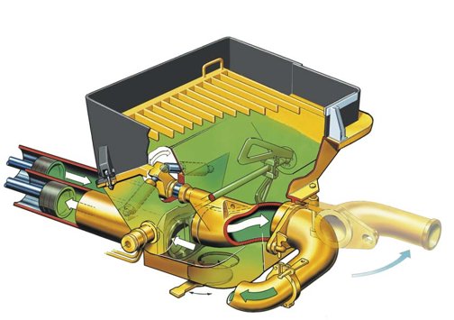
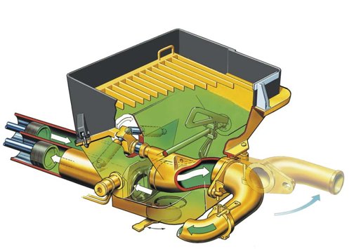
I wonder how long the service-cycle is on a Putzmeister S-Valve™, is that when the next disaster strikes?
www.pmw.deby Rob in SF via Pmw.de 5/27/2011 9:03:37 AM- @rob - surely they'll have the permanent cooling systems up and running by then as per the road map?by hudebnik 5/27/2011 9:06:42 AM
- Gov't displeased with TEPCO's flip-flop on seawater injection
TOKYO (Kyodo) -- The government expressed displeasure Thursday regarding Tokyo Electric Power Co.'s flip-flop over the injection of seawater into a nuclear reactor at its Fukushima Daiichi power plant the day after the March 11 earthquake and tsunami.
"If the facts are not accurately reported, we will be struggling as to how to respond to the situation. More than anything, the public will become doubtful" about the information released subsequently, Chief Cabinet Secretary Yukio Edano told a news conference.
Edano made the comments after the utility, known as TEPCO, said earlier in the day that water continued to be injected into the reactor on March 12, retracting its earlier announcement that it had temporarily suspended water injection on that day.
TEPCO's initial statement that the injection of seawater was suspended on the day after the twin disasters hit the complex added to the criticism of Prime Minister Naoto Kan's handling of the country's worst nuclear crisis.
(Mainichi Japan) May 27, 2011
mdn.mainichi.jpby hudebnik 5/27/2011 9:11:14 AM - @hudebnik - Surely. (And don't call me Shirley;)by Rob in SF 5/27/2011 9:11:34 AM
- :) LOL!by hudebnik 5/27/2011 9:11:56 AM
- @hudebnik - TEPCO's a FLIP-FLOPPER!by Rob in SF 5/27/2011 9:12:10 AM
- @Rob - interesting that the apparent solidarity between Tepco and the GoJ is now cracking. Clear signs of distancing now - 'It wasn't our fault, they didn't tell us'.by hudebnik 5/27/2011 9:13:43 AM
- @shirley - at least in the film they got the plane down!by hudebnik 5/27/2011 9:14:45 AM
- Kaieda to check cause of TEPCO's 'false' report on water injection
TOKYO, May 27, Kyodo
Industry minister Banri Kaieda on Friday criticized Tokyo Electric Power Co. for ''falsely'' reporting that it had temporarily suspended the injection of seawater into one of the troubled nuclear reactors at the Fukushima Daiichi power plant in March.
''I would like to check why a false report was made to the Nuclear and Industrial Safety Agency,'' the minister said, one day after the plant operator acknowledged that the emergency step to keep the No. 1 reactor cool was actually not suspended during the crucial moments in the battle to regain control of the plant hit by the March 11 megaquake and ensuing tsunami.
Kaieda, who heads the ministry that plays a pivotal role in the country's nuclear policy, said he also learned about the fact Thursday, and was ''surprised.''
english.kyodonews.jpby hudebnik 5/27/2011 9:17:47 AM - Taking a break now, back in a few hours.by hudebnik 5/27/2011 9:20:29 AM
- @hudebnik - There's been a lot of obvious positioning from day one. To be expected in this internationally litigious world. But the posturing is no longer demure.by Rob in SF 5/27/2011 9:22:30 AM
 @all g'morning I have browsed the overnight posts and come to the conclusion that everybody is trying to play their 'get out of jail free' cards at the same time - meanwhile Fuku just keeps spewing radiation.
One thing I am picking up on twitter is that GOJ are removing 'nuclear safety guidance' etc from websites I am using google translate so am not really clear , this is one of the posts
translate.googleusercontent.comby elainekirk 5/27/2011 10:28:56 AM- (Reuters) - Japan's Chubu Electric Power Co said on Friday that a lawsuit seeking a permanent shutdown of its Hamaoka nuclear plant had been filed by residents who live near the controversial facility south of Tokyo.
www.reuters.comby elainekirk 5/27/2011 10:31:42 AM - @elainekirk Morning! And yes I agree with what you have said.It really is just getting stupid now........And the media isnt helping! And I cant make out the google translate.............never can!by Angie 5/27/2011 10:32:39 AM
- @elaine I pinned a post from @Reed for you too! He thought you may like it!by Angie 5/27/2011 10:37:54 AM
- @angie I will go look thankyby elainekirk 5/27/2011 10:38:19 AM
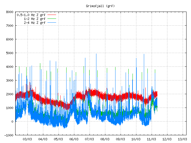
- @angie these are Grimsfjall tremor readings hraun.vedur.is near Grimsvotn Volcano so although she is sleeping again it may not be for long. @reeds link is great sattellite pics of volcano's are obviously ok for public consumption I wonder why vids of #Fukushima are not being released?by elainekirk 5/27/2011 10:47:53 AM
- @elainekirk roflmao ummmmm maybe the massive stuff ups or the rad that will haunt generations to come or the fact that its still leaking or maybe because (this is my favorite one) they dont want to cause panic???by Angie 5/27/2011 10:51:05 AM
- @angie if all the nose bleeds are symptomatic then they will have real panic on their hands because at some stage a diagnosis is going to be madeby elainekirk 5/27/2011 11:04:23 AM
- @elainekirk I just wish they would hurry up about it!by Angie 5/27/2011 11:05:22 AM
- @angie may be sooner than they think there is talk of neck glands and to hurry with diagnosis I keep translating tweets and there is a call for further evacuations so we can expect another shutting of the stable doorby elainekirk 5/27/2011 11:12:21 AM
- @elainekirk Well really I am waiting for another announcement that they are doing another dump into the sea............Everything is leaking even the treatment plant and every where is full!by Angie 5/27/2011 11:15:21 AM
- there was something earlier about how iodine was in sea samples meaning the leakage was ongoing ?/by elainekirk 5/27/2011 11:16:24 AM
- I would think that it would be but I think they may have to do a bigger dump that cant be hidden.............like the last big one they did.by Angie 5/27/2011 11:17:29 AM
- A non techi post from Steve Herman twitter.com!/W7VOA
Letter from a Fukushima mother
When Tomoko-san, a mother of two in Fukushima City, heard from an NGO worker that I was going to be in Fukushima to report on a story about radiation levels at local schools, she was kind enough to volunteer her time to speak to me – and handed me this letter. I promised to translate it and share it with you. So here it is:
To people in the United States and around the world,
I am so sorry for the uranium and plutonium that Japan has released into the environment. The fallout from Fukushima has already circled the world many times, reaching Hawaii, Alaska, and even New York.
We live 60 kilometers (37 miles) from the plant and our homes have been contaminated beyond levels seen at Chernobyl. The cesium-137 they are finding in the soil will be here for 30 years. But the government will not help us. They tell us to stay put. They tell our kids to put on masks and hats and keep going to school.
This summer, our children won’t be able to go swimming. They won’t be able to play outside. They can’t eat Fukushima’s delicious peaches. They can’t even eat the rice that the Fukushima farmers are making. They can’t go visit Fukushima’s beautiful rivers, mountains and lakes. This makes me sad. This fills me with so much regret.
Instead, our children will spend the summer in their classrooms, with no air conditioning, sweating as they try to concentrate on their lessons. We don’t even know how much radiation they’ve already been exposed to.
I was eight years old when the Fukushima Daiichi plant opened. If I had understood what they were building, I would have fought against it. I didn’t realize that it contained dangers that would threaten my children, my children’s children and their children.
I am grateful for all the aid all the world has sent us. Now, what we ask is for you to speak out against the Japanese government. Pressure them into taking action. Tell them to make protecting children their top priority.
Thank you so much,
Tomoko Hatsuzawa
Fukushima City
May 25, 2011
docs.google.comby elainekirk 5/27/2011 11:19:23 AM - @elainekirk Oh that is so sad! Tht is the stuff that needs picking up in msm! I really do not understand the world at times.by Angie 5/27/2011 11:22:18 AM

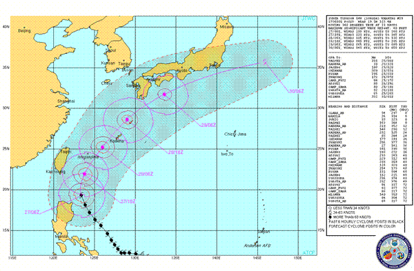
Warning forecast track- www.usno.navy.mil
Warning text- www.usno.navy.mil
Super Typhoon Songda (Possibly a High CAT 4 Typhoon)
Songda has begun to weaken over the last 6-12 hours as it undergoes an eye wall replacement(natural process of these systems, as the eye wall replaces the system loses intensity due to poorer organization of the centre, after replacement has finished the system usually re-intensifies depending on conditions), it peaked at 140kt sustained winds, gusts to 170kts. JTWC still classify the system as a Super Typhoon(CAT 5) while other analysis sites indicate the system as being a high CAT 4.- still with sustained winds at 130kts but latest Dvorak analysis (wind measurement analysis) indicate sustained winds 115kts-130kts. It continues moving north/north west but should swing north/northeasterly over the next 12 hours. The system is now located northeast of the northern tip of the Philippines, conditions are increasingly becoming unfavorable for further intensification, wind shear is increasing and the system will soon enter cooler seas, there may be a small window over the next 12 hours for the system to slightly re-intensify should the eye wall replacement cycle finish. After this time Songda will enter an area where the shear profile around system is increasingly unfavorable with an area of increasing wind shear east of Taiwan currently at 20-30kts.There is a possibility though that it may be able to push the unfavorable area of shear more northward creating a more favorable environment, current forecast and model intensities do not show this as happening however. Models remain again in good consensus short term and then split, as mentioned in JTWC warning there are two pole ward outliers and two equator ward liers with ECMWF being about the middle, the JTWC track map as always is south of consensus because of known inaccuracies but closely represents the more southerly tracks forecast by GFS & NOGAPS. JTWC also note that over the last 12 hours(latest two model runs) there has been a shift by computer modeling equator ward(south), JTWC have also used this for reasoning when using a more southerly track. Definite but minimal land interaction is now indicated by JTWC, using the models GFS & NOGAPS in comparison with JTWC one can surmise that max winds over the southern Japanese mainland to reach 65-70kts and there maybe winds as high as 50kts(very worst case!) affecting the Fukushima area, precipitation has again been scaled back by the latest model runs, there will still however be well over 100mm accumulated affecting the southern parts of Japan with sporadic heavy falls further north with most areas though only receiving 75 mm or less accumulated. Steering charts at CIMSS indicate overall the general forecast movement of the system, the current chart however does indicate a later easterly swing than indicated by JTWC, models which lie further north in later TAU’s maybe indicating that these conditions will be the prevailing forces while JTWC and the more southerly lying models may indicate that this is an analysis error or may change rapidly over the next 12 hours, also to note the more northerly tracks are the faster scenario models, their northerly track is due also to this scenario giving less time to the trough extending from mainland China to erode the steering ridge to the east preventing a greater easterly movement. The shear maps indicate the higher shear environment directly east of central Taiwan confirming the forecast reasoning of JTWC. In 24 hours (1200UTC/28th) the system should be located near or over Kadena, from this time forecasting an end location for the system and it’s affect of the Japanese mainland should be all but shore(unless there’s a dramatic change of conditions), I will at this time or thereabouts be back to write an update and try to analyze as much as possible to come up with a forecast of conditions for the Japanese mainland, it should be within reason close to correct….again barring a dramatic unforeseen change…. or of course me fuku’ing it up! Remembering…I am no meteorologist!:-)by Thunder via Usno.navy.mil 5/27/2011 11:26:39 AM good morning to allby dean 5/27/2011 11:42:05 AM
- @dean morning :)by elainekirk 5/27/2011 11:42:47 AM

Japan Earthquake | Page 1397
- Who's Blogging
-
 hudebnik
 alblee
 UKVal
UKVal Jonathan Keebler
 Oliver (ScribbleLive)
 kaykodh
 Markfm
- Angie
 Mid Valley
 Matt (ScribbleLive)
 George Gibb
- elainekirk
 PKelley
 lillymunster
- dean
 bo
bo Edano
Edano Deb
Deb- Pedro Jesus
 IanGoddard