Japan Earthquake | Page 1722
 @lillymunster report on tsunami been ordered by nisa by the 8th July - some detail of tsunami in this doc www.tepco.co.jpby elainekirk 6/22/2011 12:57:52 PM
 @lilly something to research .. I had thought the water would have gone inland some distance, perhaps up to maybe a mileby dean 6/22/2011 12:58:18 PM
 @Dean, this is the link for the draft of the water storage document. wp.meby lillymunster 6/22/2011 12:58:24 PM
- ty lilly..by dean 6/22/2011 12:58:41 PM
- @dean I will see what I can find and if those back areas were impacted or remained dry.by lillymunster 6/22/2011 12:58:50 PM
- Does anyone have a link to the SimplyInfo facebook page Veenie made?by lillymunster 6/22/2011 12:59:58 PM
- @lillymunster @dean hang on I found some more tsunami here www.tepco.co.jp and here www.tepco.co.jp this one has plenty detail
Of course we need to bear in mind that after submitting these two NISA ordered that Teoco clarify some of the details (see link below)by elainekirk 6/22/2011 1:00:06 PM - I don't have that lilly.. on the veenie linkby dean 6/22/2011 1:00:47 PM
- ty elaineby dean 6/22/2011 1:00:49 PM
- can you tell my daughters have gone out and left me aloneby elainekirk 6/22/2011 1:02:55 PM
- good finds elaine (all alone with no daughters)by dean 6/22/2011 1:04:26 PM
- @lilly.. is that simply info on facebook an approved link ?by dean 6/22/2011 1:06:27 PM
- I must go get ready.. this morning I go give blood.. I'm blessed to have the blood type that premature babies need... be backby dean 6/22/2011 1:06:54 PM
 I am AB + so I can Use any blood but few can take mine.by Ralph Unger 6/22/2011 1:08:51 PM
- I still donate as other product5s can be used.by Ralph Unger 6/22/2011 1:09:24 PM
- @Dean I will keep working on the tsunami info and try to have something compiled to post later to look at and figure out if those areas are at risk.by lillymunster 6/22/2011 1:11:37 PM
- Are no premies of all blood types?by Ralph Unger 6/22/2011 1:12:29 PM
- @Elaine, do you interpret the red lines drawn on the overhead map to be where the waters stopped or something else? www.tepco.co.jpby lillymunster 6/22/2011 1:12:37 PM
- @nanc sorry wrong simplyinfo fbook link this correct www.facebook.comby elainekirk 6/22/2011 1:16:59 PM
- ty lilly,,, @Ralph.. I think it has something to do with platelets I was giving all the time and then they called for emergency giving and that's when I found out.. I guess my blood goes to salt lake city utah then is processed and send right back to where I live for immediate use...by dean 6/22/2011 1:18:32 PM
- I will have the link reviewed as soon as I finish up.. @lilly.. see you all laterby dean 6/22/2011 1:19:57 PM
- @lillymunster hard to tell without them being clearer about O.P I will go see why nisa demanded clarificationby elainekirk 6/22/2011 1:20:12 PM
- @dean sry ty for pointing out wrong fbook linkby elainekirk 6/22/2011 1:20:49 PM
- The super cesium removal system is found to only remove ONE TENTH of the cesium announcement by Tepco www.nikkei.comby elainekirk 6/22/2011 1:23:27 PM
- @Elaine, doing a bit of digging looking for a topography map.
So after they remove 1/10th the cesium what are they going to do with the water....by lillymunster 6/22/2011 1:35:10 PM  NHK is reporting it is knocking the levels down to 1/100 of starting condition, though that is only 1/10 of the initial test (which knocked levels down to 1/1000 of input levels). www3.nhk.or.jp Still considered a problem.by Markfm 6/22/2011 1:37:58 PM
 Plant decontamination not working
The Tokyo Electric Power Company is looking into why a system for decontaminating radioactive water at the Fukushima Daiichi plant is not working as expected, delaying resumption of the system's full-scale operation.
The firm on Wednesday published data showing the amount of radioactive materials that had been removed from contaminated water during a test run of the US-made system.
The data show that density of Cesium-13 and Cesium-137 dropped to only one-100th of initial levels.
An earlier test run using water with a lower density of radioactivity showed a drop to about one-1000th.
The utility had said the system would begin full-scale operation in a couple of days.
TEPCO on Tuesday began reducing the amount of cooling water injected into the plant's No. 1 to 3 reactors and is carefully monitoring changes in their temperatures.
Wednesday, June 22, 2011 21:13 +0900 (JST)
www3.nhk.or.jpby Edano 6/22/2011 1:50:20 PM- pink curtains not working .....by Edano 6/22/2011 1:51:32 PM
- megafloat not working ...by Edano 6/22/2011 1:53:01 PM
 Magical thinking not working?by bo 6/22/2011 2:03:28 PM
- Ruby slippers?by bo 6/22/2011 2:06:07 PM
 @lillymunster watchizu.gsi.go.jp topographyby Elaine Kirk 6/22/2011 2:25:26 PM
- @Elaine, your wonderful! ;-) the areas in questions appear to be 36 above sea level. I am assuming that is meters?by lillymunster 6/22/2011 2:30:01 PM
- @lillymunster Is there something we can find the known of to compareby Elaine Kirk 6/22/2011 2:36:10 PM
- @Elaine Kirk Yes, LOL. I just noticed the TEPCO report has all the infiltration levels and differences between water vs. topography so I can use that to compare to the topography map. :-) Boy do I need more coffee this morning!by lillymunster 6/22/2011 2:40:24 PM
- @lillymunster thats a relief I did find this where that originates from which may be useful in future - watchizu.gsi.go.jpby Elaine Kirk 6/22/2011 2:41:55 PM
- BTW, I have a google map of Fuku that I marked things related to the water storage paper. Thinking about making another one we can flag landmarks or what each building is.. maps.google.comby lillymunster 6/22/2011 2:48:54 PM
- @lillymunster sounds a good idea there are a few people here in fact I bet it is possible that we could get a build video showing land building quakes , big quake right up to present - that is going on what I have seen others like @Ian produce - way beyond me skill levelby Elaine Kirk 6/22/2011 2:52:53 PM
- The level in front of the turbine buildings is 8m above sea level. The area around the reactor buildings, 14m above sea level. The back areas where parking lots, recreation areas and auxiliary buildings are 34m.by lillymunster 6/22/2011 3:00:40 PM
- so they just got the topping of the tsunami then? cars can be carried in very little water, the diesel tanks were just above sea level weren't they? and the mains leccy failed due to earthquake going by those docs .... just thinking I will returnby Elaine Kirk 6/22/2011 3:09:22 PM
- @Elaine Kirk Everything down in that valley you see on the TEPCO live cam where the workers go down the stairs is where things flooded.by lillymunster 6/22/2011 3:14:06 PM
- Updated the water storage document to include the tsunami research wp.meby lillymunster 6/22/2011 3:14:30 PM
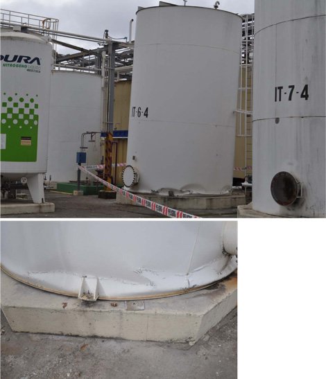
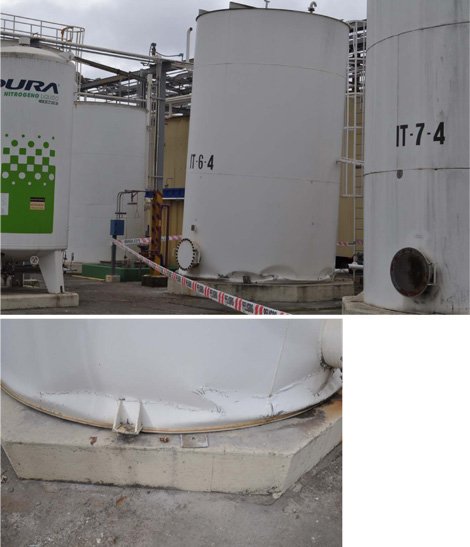
www.fema.gov
looks familiar but this is a quake damaged tank in chile no tsunamiby Elaine Kirk via Fema.gov 6/22/2011 3:14:31 PM- fema doc here that helps with what was quake www.fema.govby Elaine Kirk 6/22/2011 3:16:04 PM
- @Elaine Kirk The tanks that got it the worst are the ones anywhere in front of the turbine buildings facing the sea. The tanks tucked behind the turbine buildings had much less damage. The ones down near the docks, one was ripped off the foundation and moved and another has big twist marks at the base where the water came in.by lillymunster 6/22/2011 3:16:30 PM
Japan Earthquake | Page 1722
- Who's Blogging
-
 hudebnik
 alblee
 UKVal
UKVal Jonathan Keebler
 Oliver (ScribbleLive)
 kaykodh
- Markfm
 Angie
Angie Mid Valley
 Matt (ScribbleLive)
 George Gibb
- elainekirk
 PKelley
- lillymunster
- dean
 bo
bo Edano
Edano Deb
Deb- Pedro Jesus
 IanGoddard