Japan Earthquake | Page 2245
 Government sets up radiation decontamination team [26 August, 2011]: www.asahi.comby es 8/26/2011 9:36:42 AM
- Residents make first temporary visits to homes within 3 km of Fukushima plant [26 August, 2011]: mdn.mainichi.jpby es 8/26/2011 9:37:06 AM
- 'Glass badges' remind Fukushima students of radiation risks [26 August, 2011]: www.asahi.comby es 8/26/2011 9:37:35 AM
- Gov't nuclear watchdog criticizes TEPCO for delayed release of tsunami estimate [26 August, 2011]: mdn.mainichi.jpby es 8/26/2011 9:38:18 AM
- Radioactive water decreases at Fukushima nuke plant [26 August, 2011]: www.asahi.comby es 8/26/2011 9:38:31 AM
- Contaminated Water Treatment System Stops for the Nth Time at Fukushima I Nuke Plant [26 August, 2011]: ex-skf.blogspot.comby es 8/26/2011 9:39:44 AM
- Auction of Miyagi beef resumes [26 August, 2011]: www3.nhk.or.jpby es 8/26/2011 9:40:38 AM
- Volume of radiation screening requests for food beyond capacity of current facilities [26 August, 2011]: mdn.mainichi.jpby es 8/26/2011 9:40:55 AM
 yesterday Tepco was telling the gov that 5 & 6 were ok to restart blah-de-blah , today reading the seismic safety report it says that the buildings are quake proof etc..but wait...what is this..."detailed inspection inside the building has not been conducted yet".... HTF can they say it is safe?........ www.tepco.co.jpby elainekirk 8/26/2011 9:42:33 AM
- Fukushima to state: Buy the leftovers [26 August, 2011]: search.japantimes.co.jp
"FUKUSHIMA — The Fukushima Prefectural Government asked the central government Thursday to buy up any unsold beef that landed in the market before the July 19 ban on shipments was imposed, prefectural officials said.
The ban on Fukushima beef was imposed after local cattle were belatedly found contaminated with high amounts of radioactive cesium on a farm in Namie.
Fukushima also asked the state in writing to test all remaining cattle in the prefecture for radiation to pave the way for lifting the ban, the officials said. In addition, a new prefectural survey has determined 603 cattle were shipped for slaughter from 25 farms in the prefecture, including Namie, from March 11 until April 22, when the government finally decided to widen the evacuation zones around the stricken nuclear plant."by es 8/26/2011 9:53:34 AM - by es 8/26/2011 9:54:01 AM
- @es they are just trying to fuddle everybody twitter is saying the fuku ban was liftedby elainekirk 8/26/2011 10:01:15 AM
- @elainekirk Yes, the NHK article below on Miyagi beef mentions that:
"The government lifted the ban on Miyagi beef cattle on August 19th, saying that sufficient measures had been put in place to ensure its safety. A similar ban on beef cattle from Fukushima, Iwate and Tochigi prefectures was lifted on Thursday."by es 8/26/2011 10:06:39 AM - More, including video footage, on the Futaba and Okuma Town residents' temporary visit to their homes on Friday - 'Residents near nuke plant make temporarily return' [26 August, 2011]: www3.nhk.or.jpby es 8/26/2011 10:09:57 AM
 @es, don't know, but here's a report www.power-eng.com posted an hour ago that notes (1) "Water to cool North Anna's reactors comes from Lake Anna" and (2) "the plant's four backup diesel generators started as designed and continued to run the reactors' cooling systems." Yet the reason given for the 22-inch drop of Lake Anna is that the plant hasn't been feeding water into the lake www.wtvr.com . So the apparent implication is that there are millions of gallons that have been drown from Lake Anna by the backup generators to cool the two cores, but that have not been returned back to Lake Anna. Sup with that?!by Ian 8/26/2011 10:22:19 AM
- @es they give them cloth masks to go inside the 3km zone ! I saw them measureing the air but radiation settles the air can be fine whilst objects can be way off scale ...have I got that right?by elainekirk 8/26/2011 10:22:38 AM
- @Ian I suppose the steam cooling/dumping resulting from the shut-down releases water to the atmosphere which under normal conditions would somehow return to the lake via the turbine and condenser equipment?by es 8/26/2011 10:24:51 AM
 @HI I guess you have seen this? Ian?.. This is not good for democracy – “The Agency for Natural Resources and Energy said tweets on Twitter and postings to blogs will be monitored for groundless and inaccurate information that could inflame and mislead the public.
The agency said it is trying to "track down inaccurate information and to provide correct ones instead."”
ajw.asahi.comby Mona 8/26/2011 10:29:07 AM- @elainekirk But they were HAPPY to go home. Smiling. Immune.by es 8/26/2011 10:32:30 AM
- @es oh yes of course!by elainekirk 8/26/2011 10:38:33 AM
 Contaminated Water Treatment System Stops for the Nth Time at Fukushima I Nuke Plant : TEPCO announced on August 26 that the contaminated water treatment system at Fukushima I Nuclear Power Plant stopped temporarily. The pump that transfer the treated water from Kurion's cesium absorption system to AREVA's co-precipitation system stopped automatically at 2:21PM. The treatment system last stopped on August 12 due to the abnormal signal from the control system. TEPCO thinks the stoppage this time is due to too much load on the pump, and is currently looking into the cause. ex-skf.blogspot.comby Majj 8/26/2011 10:41:47 AM
- Oh Sorry for the repost I'm still sleeping...by Majj 8/26/2011 10:42:51 AM
- @Majj Yours is better ;)by es 8/26/2011 10:49:35 AM
- out for awhile :)by elainekirk 8/26/2011 11:01:30 AM
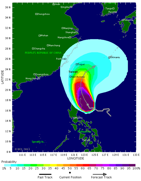
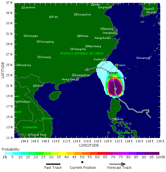
www.tropicalstormrisk.com Typhoon 14W (Nanmadol), # 4 UPDATED 3:45 p.m. Friday, Aug. 26, Japan time: Nanmadol was upgraded to a super typhoon at 9 a.m. local Friday.
"It will affect us in one form or another," an official with Kadena Air Base's 18th Wing Weather Flight said Friday. Stated another way, it's still too early to tell how much, whether Nanmadol will make a direct hit on Okinawa or pass to the west or east; forecast models aren't in agreement at this point. Much depends on what Nanmadol's wingman, Tropical Storm Talas, does to its east, but the official said to be prepared for a wild middle of the week. Winds are already starting to pick up, but the meanest parts of Nanmadol should be felt "Tuesday and Wednesday, maybe into Thursday."
Even though Nanmadol is a small storm diameter-wise and is bumping up against the Philippines’ northernmost island of Luzon, Nanmadol’s eye is still over water, very nourishing ocean heat content. As a result, it’s forecast to become a very powerful storm – peaking at 161-mph sustained winds and 198-mph gusts Friday evening. By 9 a.m. Wednesday, Nanmadol is forecast to be about 310 miles southwest of Kadena, moving northeast and packing sustained 121-mph winds and 150-mph gusts at its center.by Majj via Tropicalstormrisk 8/26/2011 11:02:53 AMThom speaks with nuclear energy expert, Paul Gunter on the unpreparedness of officials at the North Anna Nuclear Power Station in Mineral, Virginia during Monday's east coast earthquake. “I think without a question there has been structural damage to the plant” in Virginia.
by Majj 8/26/2011 11:08:21 AM I have to take anything said on RT with a grain of salt. Their coverage is as anti-American as the MSM is pro-status quo.by Hank Scorpio 8/26/2011 11:16:21 AM
- Japan PM announces resignation
Noato Kan today announced that he would resign as head of the ruling Democrat party. His resignation leaves Japan looking for its sixth leader in five years as it tries to rebuild from the massive earthquake and tsunami that caused widespread destruction earlier this year.
Mr Kan said: “It was a difficult situation with many challenges, but taking that into consideration, I believe that I was able to do everything that I should have done.” www.telegraph.co.ukby Majj 8/26/2011 11:33:08 AM  @Majj Thanks for finding the RT article.
Everyone who scrambled, researched and found the info on N. Anna earlier in the week should be congratulated. Our research and the end result article was sent to RT's production team. They told me they were going to do something with it. The Hartman piece is what they did with it. :-)
Good work everyone! :-)by lillymunster 8/26/2011 11:52:25 AM- Majj, is there any prediction on the tropical storm hitting Honshu?by lillymunster 8/26/2011 11:54:51 AM
- If Anna lake has dropped 22 inch in three days, then is time to look for cracks in it's bottom or in it's dam. In no way the NPP water circuit can produce this drop.by estacion 8/26/2011 11:55:41 AM
- @estacion ? I missed that part, was it in the video or did you see it elsewhere?by lillymunster 8/26/2011 12:03:58 PM
- Posted by Ian here, page 2 actualy.
www.youtube.comby estacion 8/26/2011 12:07:59 PM - @lillymunster Ian posted a report mentioning a 22 inch drop earlier (c.6hrs ago), and there was some discussion about what it might mean.by es 8/26/2011 12:08:02 PM
- @es thanks. That is quite concerning. The dam has a bad rating according to the RT video. I have not found newer seismic data for the area. The information from the 70's related to N. Anna said the area under the dam was unknown as far as seismic instability.by lillymunster 8/26/2011 12:13:58 PM
- *actually.
However NPP's cool circuit will be hitted when lake's water drop enough.by estacion 8/26/2011 12:15:00 PM - Clogged by mud or completely dried bottom.
It's not the first time that a lake is completely dried after a EQ.by estacion 8/26/2011 12:18:22 PM - @estacion makes me wonder if we have other NPP in the world that are dependent on artificial lakes like this one. It is not a good idea.by lillymunster 8/26/2011 12:18:32 PM
- @estacion ??? I can't watch the youtube right now, was that in the video?by lillymunster 8/26/2011 12:19:08 PM
- @lillymunster Is to early for prediction of the storm hitting Honshu. But Nanmadol have already be upgraded to a super typhoon . In 3/4 days we will know.by Majj 8/26/2011 12:21:51 PM
- @lillymunster: In the video they speak about lake's dropped about 22 inch, but image shows a very narrow and shallow place.by estacion 8/26/2011 12:25:29 PM
- @estacion These dams are clearly a real concern. I recall you mentioning the poor state of Trinidad’s North Lake Dam after the Colorado quake the other day... Hopefully the NPP inlet pipes are close to the bottom of the lake!
@lillymunster www.wtvr.comby es 8/26/2011 12:25:30 PM - @es. Yes, man made lakes are very unstable geologically speaking. They were no tested over the course of the centuriesby estacion 8/26/2011 12:28:47 PM
 Japan PM Kan announces his resignation
By Takuya Karube
TOKYO, Aug. 26, Kyodo
Prime Minister Naoto Kan announced his resignation Friday, shortly after the passage of two major bills in parliament, spinning Japan's revolving-door leadership yet again toward picking his successor next week.
''Today, I'd like to resign as head of the Democratic Party of Japan...and then once the new leader is picked, I will quickly quit as prime minister,'' Kan told a meeting of the ruling party, nearly three months after first indicating he would step down. ''While there was some harsh criticism, despite that, I am really thankful for the support you have given me.''
Kan said he has no regrets about leaving office. ''Considering I was in a tough environment, I feel that I did what I had to do,'' he said. english.kyodonews.jpby Edano 8/26/2011 12:30:27 PM- bye bye, cumpadre.by Edano 8/26/2011 12:30:38 PM
Japan Earthquake | Page 2245
- Who's Blogging
-
 hudebnik
 alblee
 UKVal
UKVal Oliver (ScribbleLive)
 Jonathan Keebler
 kaykodh
 PKelley
 Markfm
 Angie
Angie Deb
Deb Mid Valley
- Pedro Jesus
 Matt (ScribbleLive)
 George Gibb
- elainekirk
- lillymunster
 dean
dean bo
bo- Edano
 IanGoddard