Japan Earthquake | Page 1373
 they should better make groundwater readings.by Edano 5/25/2011 10:40:53 AM
- i cannot believe it. 30 years i've been fighting against nukes, 2 worst case scenarios and they still construct new ones. everybody knows what can happen, and that it will happen sooner or later. so much money spent just to ruin the earth and kill people. it is disgusting.by Edano 5/25/2011 10:45:35 AM
 @edano whilstever reporting of the negative aspects is suppressed people will continue to believe it is manageableby elainekirk 5/25/2011 10:47:42 AM
- Quake may have damaged key piping at No.3 reactor
Tokyo Electric Power Company has released data which suggests the March 11th earthquake damaged a critical piping system in the No. 3 reactor at its Fukushima Daiichi nuclear plant.
The utility said that analysis of pressure and temperature data from the days after the quake shows that the No.3 reactor lost its cooling system on March 13th. Much of its nuclear fuel likely melted down and collected at the bottom of the pressure vessel over the next 24 hours.
The analysis also shows that piping in an emergency cooling mechanism, known as a high-pressure coolant injection system, may have been damaged by the earthquake. The system is designed to maintain the water level inside the reactor vessel during an emergency.
The system is known to have automatically switched on shortly after noon on March 12th.
Pressure inside the reactor, which was 75 atmospheric pressure, plunged to about 10 atmospheric pressure over the next six hours.
Tokyo Electric says the drop in pressure is consistent with analysis which assumes the piping system had been damaged.
The piping system is one of the plant's most important structures in terms of safety, and must be damage-proof.
Tokyo Electric refuses to confirm, however, that the key piping system was damaged by the quake, and suggests that it is possible a gauge malfunction may be to blame for the data fluctuation.
Experts note that extensive investigation is needed to examine whether the massive earthquake damaged the cooling system.
Wednesday, May 25, 2011 18:46 +0900 (JST)
www3.nhk.or.jpby Edano 5/25/2011 10:47:43 AM - dean should read that.by Edano 5/25/2011 10:50:10 AM
- "Tokyo Electric refuses to confirm, however, that the key piping system was damaged by the quake, and suggests that it is possible a gauge malfunction may be to blame for the data fluctuation."by Edano 5/25/2011 10:51:23 AM
- @elainekirk : we in germany face massive press campaigns by the nuke industry right now. they keep telling us we will have blackouts without nukes, although all but 4 nukes are shut off at the moment. even the IAEA and the IAE keep warning us. the pressure is immense.by Edano 5/25/2011 10:55:53 AM
- however - blackout is better than meltdown.by Edano 5/25/2011 10:58:36 AM
- @edano with solar and wind available for backyards people should start to think how much their power is costing them compared to how much it would cost were they to provide it-people are more able to think money rationally for some strange reasonby elainekirk 5/25/2011 11:22:08 AM
 Night guys I need a early night to handle 30 rug rats in the morning lolby Angie 5/25/2011 11:41:47 AM
- @angie g'night sleep wellby elainekirk 5/25/2011 11:43:38 AM
 Morning all,
Nite Angie!by Nancy 5/25/2011 11:44:53 AM
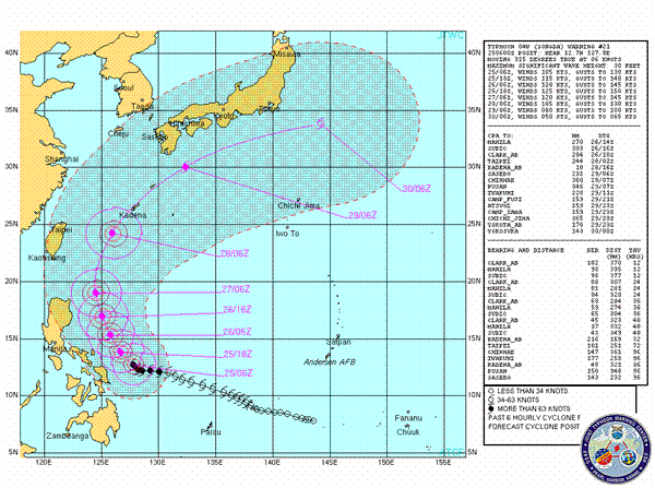
JTWC Track- www.usno.navy.mil
JTWC warning text- www.usno.navy.mil
Typhoon Songda (Category 3 system @ 0900UTC)
Currently Songda sits east off the coast of the Philippines and has begun over the last 6-12 hours turning northward (currently tracking west northwest). The system has begun deeply intensifying, strong convection continues around its core and throughout the entire system, outflow is strong and shear maps indicate that the system lies in a relatively low shear environment, however there is a small area of higher shear to the northeast and the visible sat image show signs of mild shearing, within the next 6-12 hours the system is forecast to continue rapid intensification and be classified as a Cat 4 System with sustained winds of 114kts+ as it continues its northerly movement. Recurve to the north east is forecast to begin in 48 hours or so this will project the system directly over the Ryukyu Islands with the possibility of Cat 4 winds (most likely high Cat 3; 105-113kts). Forecasts and models have not changed significantly over the last 24 hours, the JTWC warning track indicates a sharp curve away from Japan in the Later TAU’s (+96 hours) due to strong westerly’s forecast to arrive at the mid latitudes, should this occur the Japanese mainland would be spared the worst of the system, models still vary on track and intensity, however they remain tightly grouped and most indicate serious land interaction with the Japanese mainland bringing in some cases 60kt+ winds and well over 100mm of rainfall to wide spread areas. As mentioned before JTWC amend their forecast track due to known inaccuracies in the models abilities to forecast recurve scenarios and this is why currently they track the system more eastward of Japan than the models indicate. Looking at the usual analysis material at CIMSS(shear, steering winds, water vapor, ect.) the forecast track and intensity seem to be a very reasonable scenario and there seems little to indicate otherwise particularly in the next 48 hours, after that the system will move north past the Philippines, currently the wind shear profile here seems to be very unfavorable, this may improve in that time, also a system as intense as this can at times make its own conditions(basic explanation) so the unfavorable shear profile further north would not affect the system as greatly and it would be able to maintain a higher intensity much further north than currently forecast(this was seen with Aere, the forecast unfavorable shear never eventuated and hence the system maintained greater intensity further north.) Steering winds short term seem a little unsure but definitely indicate continuing northward movement, this is a good scenario for the Philippines and later on Taiwan, provided the northeasterly change in track occurs. Unfortunately the system seems sure to affect the Ryukyu Is. and Okinawa with intense Cat 3 winds. Typhoon Songda still remains at least 72 hours away from first land interaction with the Japanese mainland(as currently forecast) however it poses a very real and serious threat to Japan, should the JTWC reasoning fail or should a forecast weather condition change ever so slightly for example the driving mid latitude westerly’s that will push the system away from Japan weaken than the Japanese mainland will be very much in the firing line of a very serious weather event. Hopefully this does not eventuate! (Remembering…I am no meteorologist)by Thunder via Usno.navy.mil 5/25/2011 11:45:21 AM- @Elaine. Solar and urban wind are viable in many areas. The powers that be heavily resist anyone attempting to do this. We want to put in solar shingles, we have a huge south facing roof and a set of urban wind turbines. The dual electrical systems makes it considerably more costly and complicated. Even just getting a wood burning fire place as a low tech heat back up is almost impossible. You can not get one put into a standard home while it is being built. Builders here refuse to, but they will put in a gas fireplace.by Nancy 5/25/2011 11:47:38 AM
- @Nancy you are right business interests and governments have become one and the same you cannot get planning permissions unless they serve the interests of the monopolies :(by elainekirk 5/25/2011 11:53:18 AM
- @Nancy and @Elaine...I was wondering if could help me with something....I am looking for a topograpical map of the area of the power plant, like a fancy looking 3d google job or something there abouts? Maybe something with natural features marked would be good tooo, like streams and things? I thought I would check if either of you knew of one?by Thunder edited by elainekirk 5/25/2011 12:00:19 PM
- @elainekirk There is a psychological component involved also. Most people won't rock the boat so if someone resists an idea they will just stop. Before we bought this house we looked at building something that had alt energy integrated and a number of passive efficiency features built in. None of the technology or design was anything out of the ordinary but I had to submit an initial proposal in order to get in on a rural housing loan program. The people at the regional office had no clue what to do with it because nobody had used this option in their program. People just assume they can't use wind turbines effectively where I live. We checked the wind studies plus urban turbines don't need the type of winds the big commercial ones do. Unless your highly motivated or a total geek most people just assume it is all to strange and won't work.by Nancy 5/25/2011 12:00:51 PM
- @Thunder I have not found one myself but there likely is one. Let me ask the hubby the map geek.by Nancy 5/25/2011 12:01:45 PM
- @Thunder The hubby said USGS has topographical maps of at least the US, they might have ones of other countries available to the public.by Nancy 5/25/2011 12:03:12 PM
- @Thunder, Google earth has a topographical option. Look for layers or terrain mode. If you find something I would love to take a look at it. There are a few things I am wondering about.by Nancy 5/25/2011 12:05:38 PM
- @nancy I would like to look into urban wind turbines could you give me a link please?by elainekirk 5/25/2011 12:05:57 PM
- @Nancy...thanks heaps! @Elaine thanks too! @All I would like to add something too on the weather....I am usure about it though, namely what possible effects exist depending on the scenario, what I do know though...... storm surge and radioactive water don't mix! If they are almost out of storage and plan a dump Friday/Saturday ahead of a storm and possible storm surge(worst case) Sunday/Monday......well! And I would add too, I really can't tell much about a storm surge here, what areas gets affected and what areas don't, what size it maybe ect. but I thought I should mention something?by Thunder 5/25/2011 12:08:34 PM
 Hi @Nancy/Lillymunsterby hudebnik 5/25/2011 12:10:10 PM
- @elainekirk www.motorwavegroup.com - urban turbinesby Nancy edited by elainekirk 5/25/2011 12:12:05 PM
- @nancy - Please could you pin the Tepco historic data page for me? It is very relevant at the moment, but a bit buried in the faqwiki. Pin follows:by hudebnik 5/25/2011 12:13:27 PM
- TY!by hudebnik 5/25/2011 12:17:10 PM
- @all, don't forget to vote for the group name today! Voting ends in about 13 hours. Link to vote is pinned above.by Nancy 5/25/2011 12:17:59 PM
- @nancy tyby elainekirk 5/25/2011 12:19:12 PM
- As they used to say in Northern Ireland - vote early and vote often.by hudebnik 5/25/2011 12:20:23 PM
- @Elaine, also google vertical axis wind turbines. There are tons of DIY pages online to make one out of common items. I didn't find the specific one I was after but there are tons of them.
@nancy that is great ty I have bookmarked to read on my return from app with bank - if I survive itby Nancy edited by elainekirk 5/25/2011 12:20:44 PM  @Edano-RE:Tepco news release; "Tokyo Electric refuses to confirm, however, that the key piping system was damaged by the quake, and suggests that it is possible a gauge malfunction may be to blame for the data fluctuation." "Pressure inside the reactor, which was 75 atmospheric pressure, plunged to about 10 atmospheric pressure over the next six hours""
I would like to make the following observation of the BS that is being spun by the above quotes: When pressure guages(digital or analog) fail they do so instantaneously and not gradually over 6 hours!!!!!!!....by Lethbridgean 5/25/2011 1:02:00 PM- @Lethbridgean - most of the gauges were giving very strange readings around that time, but it seems inconceivable that they had all failed. www.houseoffoust.com has all the sensor details, and the graph at www.houseoffoust.com shows a spectacularly unstable reactor. What the operators were making of it is anyone's guess!by hudebnik 5/25/2011 1:14:38 PM
- I think we will get a real answer in about a week just because that seems to be TEPCO's standard procedure. They seem to be rushing the truth out ahead of GoJ and UN investigations to keep themselves from being caught lying.by Nancy 5/25/2011 1:18:16 PM
- @nancy - yes the IAEA investigating team is there now.by hudebnik 5/25/2011 1:19:35 PM
- They are being pushed into a corner as these investigations find thingsby Nancy 5/25/2011 1:20:26 PM
- And as the situation continues to develop.by hudebnik 5/25/2011 1:24:24 PM
- @hudebnik - I am well aware of Nancy's charts. I fail to understand why you think the reactors wouldn't be unstable in those first six hours. Chernobyl only needed 1 hour of having no coolant flow to upset the balance of the system to start the process of a meltdown.The balance of a NPP is a precarious one.by Lethbridgean 5/25/2011 1:24:46 PM
- I have two questions.
1. Could they just drop a hose into the flooded lower levels, run it to a pump and use that to water the reactors?
2. If you were in charge of this mess what would you do to solve the water problem?by Nancy 5/25/2011 1:27:30 PM - @Lethbridgean - oh I don't, I'd expect it. Indeed, after operational errors
Chernobyl went pearshaped in seconds www.world-nuclear.orgby hudebnik 5/25/2011 1:32:54 PM - @hudebnik - So what was your point with your rebuttle then? Do guages(digital or mechanical) fail gradually or spontaniously? IYHO. I also fail to understand why the IAEA investigation is the be all and end all in this matter. How long did it take for that organization to raise the severity level of this disaster? Who is investigating the IAEA? I think that they are as guilty as TEPCO in the handling of this fiasco. @Nancy- who are you asking the questions to? My answer to the first one is NO. And the second question was already answered by me months ago. Inject (by way of a hot tap) a cement and boron mix directly into the reactor until it pours from the leaks. Once the emissions have ceased encase the whole complex in cement.by Lethbridgean 5/25/2011 1:47:40 PM
 good morning to one and allby dean 5/25/2011 1:49:02 PM
- @Lethbridgean I don't know of anyone who has much faith in the IAEA being impartial or particularly effective in this but it does seem to have the benefit of putting TEPCO in a wringer. Having things disclosed by the IAEA is bad PR so they are trying to beat them at releasing info to save face.by Nancy 5/25/2011 1:49:56 PM
- Morning Dean!by Nancy 5/25/2011 1:50:00 PM
- @Nancy - I agree with the timing of the press releases.by Lethbridgean 5/25/2011 1:50:43 PM
- Morning Dean.by Lethbridgean 5/25/2011 1:51:05 PM

Japan Earthquake | Page 1373
- Who's Blogging
-
 hudebnik
 alblee
 UKVal
UKVal Jonathan Keebler
 Oliver (ScribbleLive)
 kaykodh
 Markfm
- Angie
 Mid Valley
 Matt (ScribbleLive)
 George Gibb
- elainekirk
 PKelley
 lillymunster
- dean
 bo
bo Edano
Edano Deb
Deb Pedro Jesus
 IanGoddard