Japan Earthquake | Page 1386
 @hudebnik good morningby Bobby1 5/26/2011 10:52:44 AM
 @Maureen g'D morningby RBeaner 5/26/2011 10:56:34 AM
- @elainekirk got the post (thanks) if you want to take it downby fitter 5/26/2011 10:57:40 AM
 @bo tyby elainekirk 5/26/2011 11:00:10 AM
 good morning to every one..by dean 5/26/2011 11:01:10 AM
- @fitter I have a couple links for you to check outby dean 5/26/2011 11:01:20 AM
 Morning @deanby hudebnik 5/26/2011 11:01:46 AM
- morning hudegnikby dean 5/26/2011 11:02:23 AM
- hudebnik.. oops.. just woke up ..by dean 5/26/2011 11:02:36 AM
- :)by hudebnik 5/26/2011 11:02:48 AM
 Good morning @deanby bo 5/26/2011 11:04:15 AM
- gm bo, good to see youby dean 5/26/2011 11:05:51 AM
- @dean g'morningby elainekirk 5/26/2011 11:06:13 AM
- www-pub.iaea.org check this out Fitterby dean 5/26/2011 11:06:55 AM
- good morning elaine.. is thekettle on.. I need coffeeby dean 5/26/2011 11:07:06 AM
- www.iasmirt.org check this out Fitterby dean 5/26/2011 11:07:58 AM
- @Bobby ok. What you know…I guess I have to try to look up what that means. ;) When I followed link from Nature, I came to ZAMG’s plume spread, so I presume both ZAMG and NILU got their info from CTBTO then – I wonder how realistic their worst case scenario animations are – didn’t look good. Hope they will put it back up at the internet – when the got more info they said..by Mona 5/26/2011 11:09:51 AM
- www.sumofallfears.com good read on bwr mark 1 primary containment failure dynamics on secondary containmentby dean 5/26/2011 11:21:42 AM
- USA, Australia and Sweden instructed their citizens to evacuate a radius of minimum 80 km. South Korea advised to leave farther than 80 km and to have plans to evacuate by all possible means.[382][383] Spain has advised their citizens to leave an area of 120 km. Embassies of France,[384] UK,[172][385] Germany,[386][387][388] Switzerland,[389] Austria,[390] Italy,[172] Australia,[172] New Zealand,[391][392] Finland,[393] Kenya,[394] Israel[395] advised their citizens to leave even the metropolitan area of Tokyo.[396][397]by dean 5/26/2011 11:25:43 AM
- my last comment was at initial accident when boundary radius was setby dean 5/26/2011 11:26:11 AM
- Dean, so these were the historic statements of evacuation from March?by bo 5/26/2011 11:26:52 AM
- yes boby dean 5/26/2011 11:29:26 AM
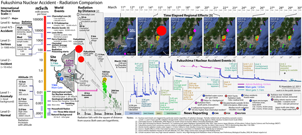
FUKUSHIMA RADIATION COMPARISON
by dean 5/26/2011 11:31:49 AM- en.wikipedia.org this is a pretty good overall information piece on wiki..by dean 5/26/2011 11:32:32 AM
- gotaa go visit bank see you all soonby elainekirk 5/26/2011 11:32:37 AM
 Some newer models in the Scirocco symphony, like...
Tracer field 1 (emitted directly in the sea - dissolved element )
sirocco.omp.obs-mip.frby Rob in SF 5/26/2011 11:34:50 AM- be safe elaineby dean 5/26/2011 11:35:31 AM
 Here's a heavy story: www.telegraph.co.ukby bojack54 5/26/2011 11:36:39 AM
- All quiet on the western front...
eurdepweb.jrc.ec.europa.euby Rob in SF 5/26/2011 11:43:35 AM - From Kyodo:
A-bomb survivors group adds 'no nuke plants' to its platformby bo 5/26/2011 11:44:14 AM
NAGASAKI, May 26 (AP) - (Kyodo)—A group in Nagasaki supporting survivors of the 1945 U.S. atomic bombing will formally add opposition to nuclear power plants to its platform for the first time since its establishment in 1956, a group member said Thursday. "Survivors of the atomic bombings are suffering from radiation-induced damage even after 66 years. The issue of nuclear plants is no longer someone else's affair," said Hirotami Yamada, secretary general of the Atomic Bomb Survivors Council.
The council, which endorsed the new policy for fiscal 2011 during its gathering Wednesday, also confirmed they will urge authorities to reveal facts concerning damage by radiation leakage accidents at the Fukushima Daiichi complex and to pay full compensation to those affected by the crisis.by bo 5/26/2011 11:44:37 AM- bo.. I like the part on "to pay full compensation"by dean 5/26/2011 11:47:48 AM
- www.scribd.com Nancy.. please put this in with the TECNICAL MANUAL FOR THE BWR. tyby dean 5/26/2011 11:49:44 AM
- @dean well in Japan, few can speak with such respect and authority on the subject. If the hibakusha finally begin to attack nuclear power, that could really have a pronounced affect.by bo 5/26/2011 11:50:22 AM
- Back in a bit folks.by bo 5/26/2011 11:50:40 AM

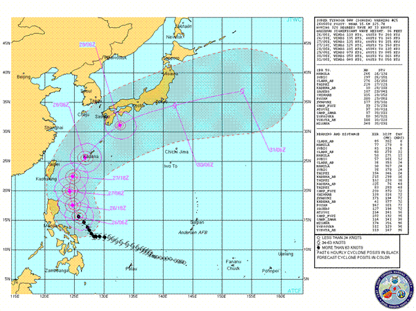
Latest forecast track(note moved northward again)- www.usno.navy.mil
Latest warning text-http://www.usno.navy.mil/NOOC/nmfc-ph/RSS/jtwc/warnings/wp0411web.txt
Super Typhoon Songda (Cat 5 @ 0600UTC)
Songda has increasingly intensified over the last 24 hours due to favorable conditions, a low shear environment exists well around the system, a defined eye on msat images indicate this as does the shear analysis @CIMSS. Water vapor conditions remain favorable also, JTWC notes the restricted Pole ward outflow, this may indeed be the only influence that will prevent the system from reaching a strong category 5(Super Typhoon), currently projected to only just make a CAT 5 system with sustained winds of 135kts gusts to 165kts. The pole ward outflow does not look like having the ability to increase with a relatively unfavorable shear profile to the north a head of strong westerly winds, the system however may be able to overcome this with further northward movement but is not progged to. The strong mid-latitude westerly’s blowing from mainland China are the biggest influence on the end result of this system, should they be weaker than forecast or should the system manage to push the interaction zone further northward then it would be a more favorable environment for direct land interaction with the Japanese mainland with higher intensity. Currently the westerly’s appear to lie just north of Okinawa @ ~30kts. Steering wind charts @ CIMSS indicate continued northward movement, model consensus to +36 hours continues to be represented by the JTWC track map, JTWC again mention the use of corrections because of known inaccuracies for their track in later TAU’s +36 hours, models currently predict a tight but varied forecast, their tracks and intensities vary slightly but all models that I have checked indicate land interaction with Japan predominately with the southern tip at least but most indicate a widespread crossing of the mainland. Wind intensity is consistently indicated as being as high as 70kts during land crossing, models have in their latest run however scaled back the size of the rain event associated with the system should it cross the mainland, the precipitation forecasts still remain high @ 100mm+ accumulated for widespread areas of southern to central Japan but have been scaled back to around 20-50mm accumulated for central to northern areas. This is good news but still a great threat to any area that will be potentially affected. Some models also have lessened the forecast strength of the westerly’s, originally forecasting for 50kts around Okinawa now forecasting around 30kts(confirmed @ CIMSS), this again may change the result. Super Typhoon Songda is a very intense system now, while it will always inevitably loose strength during its northern travels it has the potential to be a very serious weather event for Japan, currently the hope is that JTWC have the right forecast numbers for their “correction” and the system tracks off shore from Japan. Short term however, the system will most definitely affect Ryukyu and Okinawa, with possible winds as high as 125kts and significant rain, and now seems most likely to affect the southern tip of the mainland of Japan.by Thunder via Usno.navy.mil 5/26/2011 11:50:50 AM- Cheers @boby hudebnik 5/26/2011 11:50:58 AM
- by Rob in SF 5/26/2011 11:54:30 AM
- Would be nice for the IAEA to give a full update. Now 20 days later...by Rob in SF 5/26/2011 11:55:20 AM
- back in a bitby dean 5/26/2011 11:57:10 AM
- @all - just been updating the flash w pink &blue page on the wiki. Anybody know what time @radioguy might appear? I need some tech help with further research.by hudebnik 5/26/2011 12:05:34 PM
- Satellite typhoon: tenki.jpby Rob in SF 5/26/2011 12:07:28 PM
 @hudebnik I usually see him in a few hours then in about another 8 or so.by Nancy 5/26/2011 12:13:36 PM
- @nancy - tyby hudebnik 5/26/2011 12:15:54 PM
 TEPCO: Possible Water Leak Detected at Fukushima Storage Building nuclearstreet.comby Majj 5/26/2011 12:29:03 PM

Japan Earthquake | Page 1386
- Who's Blogging
-
 hudebnik
 alblee
 UKVal
UKVal Jonathan Keebler
 Oliver (ScribbleLive)
 kaykodh
 Markfm
 Angie
Angie Mid Valley
 Matt (ScribbleLive)
 George Gibb
- elainekirk
 PKelley
 lillymunster
- dean
- bo
 Edano
Edano Deb
Deb- Pedro Jesus
 IanGoddard