Japan Earthquake | Page 651
 Is this new? www.meti.go.jpby NHK Listener 4/12/2011 5:37:24 AM
 @lisat131 YES, the shallower, the more damageby VeenOui 4/12/2011 5:40:37 AM
 @VeenOui does a difference in depth mean it is a different fault line or can it be the same line?by lisat131 4/12/2011 5:42:30 AM
 I was kinda happy to see that 4+ off the Oregon Coast (I'm going to take a flyer here and say that looks like an extension of the San Andreas fault) because there's SO much happening on the other side of the rim, and while so many, so much smaller quakes happening here in California.by radioguy 4/12/2011 5:42:47 AM
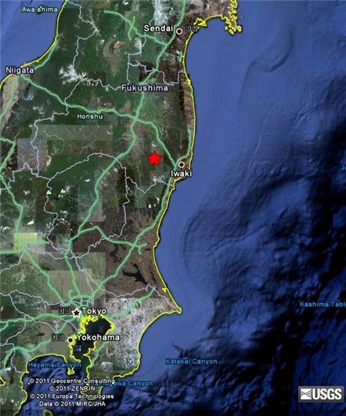
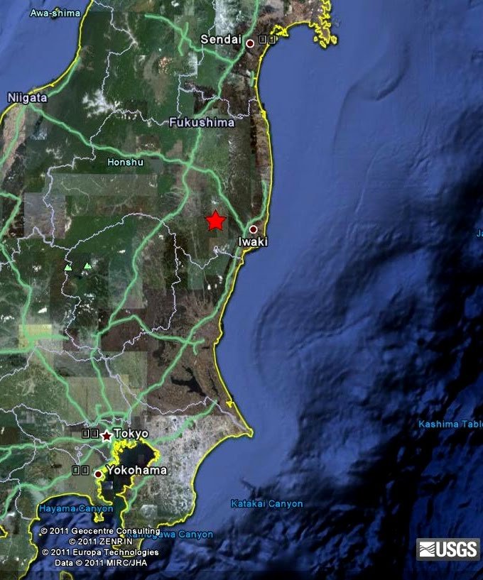
6.0 - Tuesday, April 12 @ 02:07PM at epicenter
sites.google.com
earthquake.usgs.govby openmind via Sites.google 4/12/2011 5:48:34 AM @lisat131 Yes, that is what I was thinking.by borrrden 4/12/2011 5:48:58 AM
- @lisat131 no, the depth is usually the same fault, the location makes the differenceby VeenOui 4/12/2011 5:49:42 AM
 @radioguy As someone in Oregon, I'm not too happy about the quake off our coast. That's a subduction zone, connected only loosely to the San Andreas. It's a lot like what's off the coast of Japan. Damn scary.by bojack54 4/12/2011 5:49:51 AM
- by bojack54 4/12/2011 5:50:21 AM
- Katz is reporting that the GoJ is warning to be prepared for more quakes in the 7 plus range. I hope this is not based on their prediction system, which has been somewhat accurate lately. Although it doesn't give much warning.by lisat131 4/12/2011 5:52:12 AM
- @lisat131 I downloaded an APP and it is set in Fukushima 600km radius it's been going off with 4 magnatudeby VeenOui 4/12/2011 5:53:59 AM
- @VeenOui is the app a predictor?by lisat131 4/12/2011 5:54:42 AM
- @VeenOui That's a crazy setting, it must be going off every hour or so....by borrrden 4/12/2011 5:54:50 AM
- @lisat131 yes Pre Warningby VeenOui 4/12/2011 5:55:42 AM
- @VeenOui how much lead time does it give you?by lisat131 4/12/2011 5:56:06 AM
- @borrrden depends what magnatude you put it on, when i ghoto bed, i change it to 7 +by VeenOui 4/12/2011 5:56:13 AM
- @lisat131 Don't know yet....so far i for pre warning lebvel 1.guess that means not aactive.still figuring it outby VeenOui 4/12/2011 5:56:55 AM
- www3.nhk.or.jp TEPCO reports that the earthquake had no effect on the external power and that water pumping is continuing as usual.by borrrden 4/12/2011 5:57:01 AM
- @VeenOui Yes, but you said setting it to M4 haha. My alarm is set for within 200 km of my location with M6 or above or seismic scale 5- or above.by borrrden 4/12/2011 5:57:47 AM
- @VeenOui sounds fascinating. I have seen Katz reporting where he gets a pre-notice and within just a minute or 2 he feels a quake.by lisat131 4/12/2011 5:58:21 AM
- @borrrden I am testing it.changing setting once i know how it works.i went through 5 apps and none of them were configurable to fukushima cept this oneby VeenOui 4/12/2011 5:59:33 AM
- @VeenOui Are you running a phone based one? Or browser based?by borrrden 4/12/2011 5:59:58 AM
 files.me.com During seven days of April 05, 2011, elementary and middle school playground and 1,600 kindergartens and nursery schools in Fukushima Prefecture systematically measured height over 1m points in the regional distribution of radiation dose rate.
The colored ○ represents the dose rate at each observation point. Also, within about 5km radius from where the measurement is based on measurements, the dose rate distribution in the interpolated color space, (1μSV / h each), adding to the contour lines.
Lowland region along the Mediterranean Nakadori Fukushima, higher than the surrounding area can be seen that the dose rate (in the background terrain is a figure on the next page.) The northeastern part of Fukushima Prefecture (near the village Iidate) they found areas of high dose rate is very red
That is, the spatial extension is relatively small stations in the region, and high dose rate values (10μSv / h above) is due to interpolation error, the true distribution more narrow complex it is likely to shape
Be careful.
The original data obtained from the dose rate can www.pref.fukushima.jp
Drawing on data, together with the address of the location coordinates measured by volunteers on the Internet (https: / / sites.google.com/site/radmonitor311/home than can be obtained) was used.
Drawing censure: Ishihara Yoshiaki (RISE / NAOJ) twitter @ Ishihara_Yby Bobby1 4/12/2011 6:00:15 AM- Japan just had another 6.0by wtm 4/12/2011 6:00:46 AM
- @borrrden Androidby VeenOui 4/12/2011 6:02:19 AM
- @radioguy, just had 2 in Washington. 2.1'sby wtm 4/12/2011 6:03:01 AM
- @VeenOui I use Android as well, the app I use is called "Namazu alert" It is slightly clunky but the alarm goes off without fail.by borrrden 4/12/2011 6:03:15 AM
- @borrrden that's the one :-)by VeenOui 4/12/2011 6:03:38 AM
- I'm starting to see the quakes walking up the West coast. if that's the case were in big trouble as that means this fault is really breaking off and it's really going to move....by wtm 4/12/2011 6:08:20 AM
- Washington quakes just NW of Mt. Ranier.by wtm 4/12/2011 6:12:08 AM
- @wtm earthquake.usgs.govby NHK Listener 4/12/2011 6:12:50 AM
- @wtm have the Oregon quakes mostly been offshore? And, does that relate to San Andreas...I didn't think it extended that far north. What about recent volcanic activity...any increases?by lisat131 4/12/2011 6:13:17 AM
- @lisat131 I live in washington as wellby NHK Listener 4/12/2011 6:16:50 AM
- @Lisat, NHK, might try this one.... interactive... quakes.globalincidentmap.com Yes the fault line tapers off the coast around Oregon, then goes up to Alaska.by wtm 4/12/2011 6:19:59 AM
- @NHK Listener it has been about 20 years since I lived in OR and prior to that L.A., what is the current thinking on the most likely area to have a major quake? It seemed that when I lived in OR, it was there and when I was in So. Cal, it was there.by lisat131 4/12/2011 6:20:42 AM
- You can scroll down and get the list of quakes on that map.by wtm 4/12/2011 6:20:54 AM
- @wtm that map makes the Rainier area quake look very unrelated to the other line of recent quakes.by lisat131 4/12/2011 6:22:53 AM
- @Lisat, San Andreas fault line, anywhere between Baja California (mexico) , through Los Angeles to San Francisco. That is where the majority of the west coast quakes are at, except for Alaska.by wtm 4/12/2011 6:23:09 AM
- @Lisat, notice the quakes in Arkansas, Kentucky, Montana, something weird is happening !!by wtm 4/12/2011 6:24:04 AM
- @wtm I think a couple days ago there was a line of quakes throughout that area, it was indeed weird. I am never surprised by quakes in the Montana/Wyoming region. I think the Yellowstone caldera is pegged to be the single most devastating event in modern history.by lisat131 4/12/2011 6:26:38 AM
- @Lisat, a lot of small quakes in a condensed area is showing tears of the earth as the plate is moving, that's actually a good thing, it means it IS tearing away. What you don't want is a Stress fracture quake where is\t loads up and then snaps loose, those are the big and damaging ones. West coast is moving west away from California, Japan is different the Pacific plate is pushing up under the plate under Japan, that is why the quakes there are higher and more damaging.by wtm 4/12/2011 6:28:01 AM
- @wtm after living in Oregon and CA, I moved to Missouri and learned about the New Madrid fault. I just can't run away, LOL. Now I live in FL and have ONLY had to live through 1 direct hit from a major hurricane...in other words don't follow me! :)by lisat131 4/12/2011 6:28:56 AM
- Only thing you can say when you look at that map, and that is only the last 24 hours, is that something major is happening and I don;t think that it is over yet ?by wtm 4/12/2011 6:29:23 AM
- @Lisat, If we start getting them here in Phoenix, then we know something is REALLY going on !!by wtm 4/12/2011 6:30:25 AM
- I've noticed that the Caribbean Sea is active again, also. Where I live in FL would not tolerate a tsunami...at all.by lisat131 4/12/2011 6:32:12 AM
Japan Earthquake | Page 651
- Who's Blogging
-
 hudebnik
 alblee
 UKVal
UKVal Oliver (ScribbleLive)
 Jonathan Keebler
 kaykodh
 PKelley
 Markfm
 Angie
Angie Deb
Deb Mid Valley
- Pedro Jesus
 Matt (ScribbleLive)
 George Gibb
 elainekirk
 lillymunster
 dean
dean bo
bo Edano
Edano IanGoddard